Steven R. Simms
Emeritus Professor of Anthropology
Utah State University, Logan
Based on:
Simms, Steven R. 2008/2016 Ancient Peoples of the Great Basin and Colorado Plateau (with original artwork by Eric Carlson and Noel Carmack). Routledge, New York.
The Fremont culture was borne of indigenous Archaic foragers interacting with immigrant Puebloan farmers moving north across the Colorado and San Juan rivers from New Mexico and Arizona. Through a multiethnic/multilinguistic process that spanned the centuries from A.D. 0 to A.D. 500, Fremont maize farmers became a distinctive variant of the Puebloan Southwest, reaching peak populations in the 11th and 12th centuries.
Fremont was indeed a culture with unifying themes in rock art, common styles of pottery for storage and cooking, basketry techniques, stone and adobe architecture, and distinctive sandals and moccasins. But the Fremont landscape was large and there was surely a mosaic of ethnic groups, tribal associations, linguistic variation, and local lifestyles. Fremont is an archaeological label, not a homogenous “people”.
Archaeologists first identified the Fremont in 1928 near Torrey, Utah and named it after the Fremont River. Archaeologists recognized similarities between Fremont and the Puebloan cultures of the Southwest. They also saw links between the Fremont and the preceding Archaic cultures. The roots of Fremont cultural diversity are found in their origins. Maize was brought north into Utah by Puebloan Southwestern cultures called Basketmaker II. The Colorado Plateau portion of Utah saw immigrants from Eastern Basketmaker, Kiowa-Tanoan language speakers whose descendants are the Tiwa, Tewa, and Towa Puebloans of northern New Mexico. Central Utah and the eastern Great Basin portion of Utah was settled by the Western Basketmaker II who spoke a Uto-Aztecan language that includes Hopi and the living Utah tribes Ute, Southern Paiute, and Shoshone.
The earliest traces of maize known in Utah date to about 100 B.C. in the Sevier Valley. Over the next few centuries maize appeared in the Uinta Basin, San Rafael Swell, Nine Mile Canyon, the upper Escalante River as Basketmaker II outposts in a wilderness of foragers. By A.D. 500 maize had spread to the Wasatch Front and the valleys along Interstate 15 all the way to Cedar City. Fremont occurs across Utah, and in eastern Nevada, southeastern Idaho, and northwestern Colorado. After A.D. 900 the landscape became a sea of farmers and the forager lifeway faded as the indigenous people were absorbed and changed. The transition from hunting and gathering to farming ushered in a fundamental transformation of place in ancient Utah. Place became more exploitive and circumscribed during Fremont times. Territory became more owned.
Although the foraging lifeway persisted at times and in places among the Fremont, more and more people gathered into villages as they had never done before. The best watered places harbored villages of a dozen to several dozen homes. In modern times, many Fremont villages lie buried underneath Utah’s oldest cities and towns because the Utah Pioneers chose the best places for farming, often using irrigation, as did the Fremont over 800 years earlier (Figure 1).
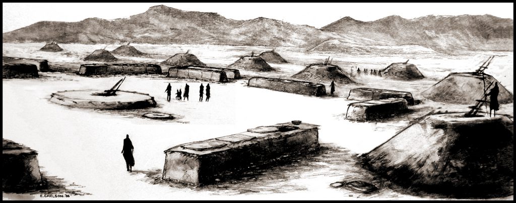
Figure 1: The Big Village at Paragonah
The site at Paragonah was excavated by Neil Judd in 1916-17 and again by Clement Meighan in the 1950s. They found an arrangement of large adobe granaries around a courtyard with a large semi-subterranean structure in the center. To the extent the Fremont parallel the cultures of the Southwest, this large structure may have been a community building of ritual and clan significance. Smaller, residential pithouses were scattered about. No one knows the exact look of the Paragonah site, but this reconstruction serves as a reminder that large Fremont villages existed. Since archaeologists tend to excavate small sites, or only tiny portions of large sites, it has taken a long time to recognize that villages were not the exception, but a common part of Fremont society. Villages of dozens and possibly several hundred people were scattered in central locations around the region, but especially along the eastern rim of the Great Basin from Cedar City, Utah to Preston, Idaho. Most of these are either buried or destroyed by modern towns and cities because the big villages occupied the same places chosen later by Euroamerican pioneers for irrigated farms and associated towns. Artwork by Eric Carlson.
Indeed, some of the Utah Pioneers were aware they were building their irrigation canals upon ancient ones. While some Fremont villages were sizable, most were small farmsteads, or “rancherias” consisting of a few homes clustered together (Figure 2). Among the homes were outdoor activity areas, and probably ramadas for shade.
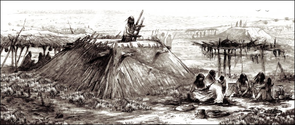
Figure 2: A Fremont Farmstead/Rancheria
This is a small Fremont village occupied by about two dozen people. That roofs of pithouses were commonly used for daily activities is shown by the number of artifacts found on top of the roof fall when pithouses are excavated. Most activities were carried on outside, hence ramadas were probably common, as were outdoor hearths, and racks for drying meat, roots and even maize. This area may have been wooded at one time, but most of the trees around Fremont residences would have been quickly used up for building and especially for fuel wood. Waffle-shaped agricultural plots cover the slope in the background, but would only be located on such slopes when the groundwater situation was favourable. Other fields were placed along the floodplain of the stream. The people at this rancheria were likely part of a dispersed community anchored by a village, and managed through a network of social connections, and hierarchy. Artwork by Eric Carlson.
There were racks for hanging things, caches of gear, caches of raw materials, and the refuse dumps humans everywhere create. Embedded in some of the larger villages were public communal storage structures made of adobe. At farmsteads and hamlets storage was typically inside the houses and hence less public. In still other intriguing instances, storage was remote from the residences and situated on cliffs for defense and a show of ownership and power (Figure 2 and 3).
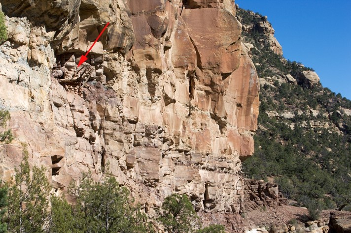
- Figure 3: Range Creek Canyon: Again, in full view, but difficult to access undetected. Courtesy of Francois Gohier.
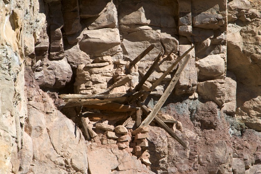
- Figure 4: Range Creek Canyon. Detail of wood and stone granary. Courtesy of Francois Gohier.
The primary Fremont dwelling was the pithouse. A basement-like structure, pithouses were capacious, functional, warm in the winter, and cool in the summer. Pithouses were excavated into the ground from a few centimeters to over a meter deep. A log and pole roof supported by vertical posts (a four-square pattern is common) extended the structure well above the ground. When finished with a lattice of smaller wooden roofing material and finally an earthen seal, pithouses looked like low mounds, or truncated pyramids with a flat roof that provided a convenient and elevated outdoor living space. Pithouses had central heating, places for storage, and a ventilation system (Figure 5).
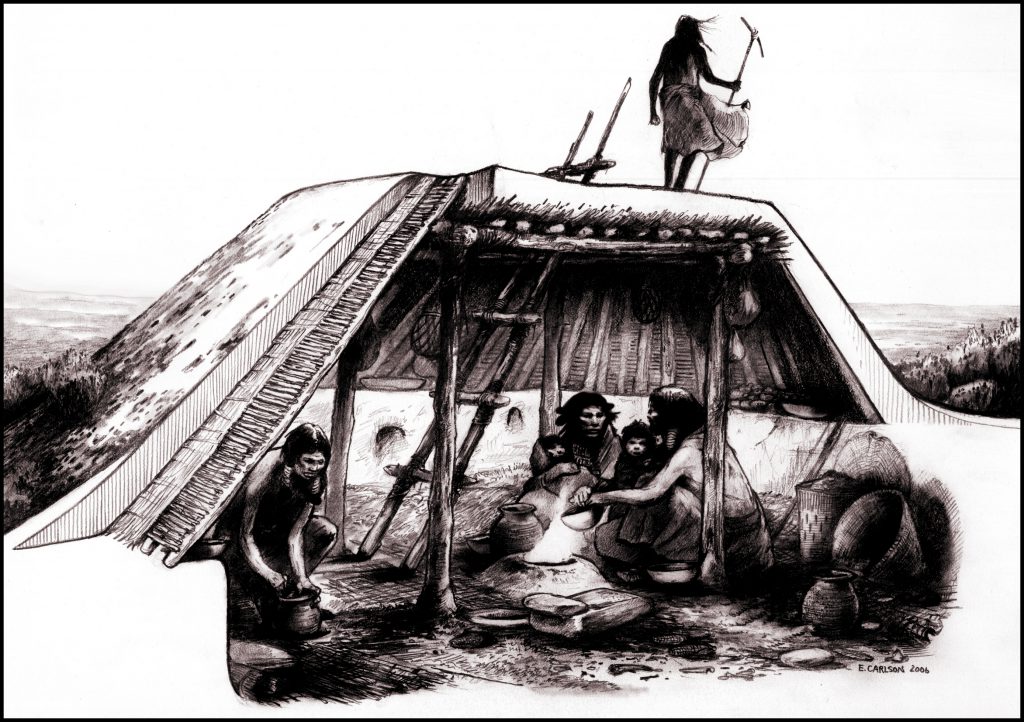
Figure 5: A typical Fremont pithouse with a four post support pattern, leaner poles overlayed with a lattice, and a shell of mud and dirt. Many pithouses were not as deep or as substantially roofed as this one. The central fire hearth is typical as are sand filled basins in the floor used to support curved bottomed pots. Pithouses are used around the world, and tend to correspond with societies that are semi-sedentary and moving among several homes each year, or moving every few years. Round pithouses indicate more mobility while the square pattern indicates more settling. The average life of a pithouse was about a decade and many ended with accidental, or in some cases, intentional burning. This pithouse is a hub of activity as demonstrated by the large “Utah type” metate, pots, basketry, gear hanging from the rafters, and debris on the floor from the work that had to be done every day. Fiber mats may have been used as carpeting. Artwork by Eric Carlson.
Flooding of Great Salt Lake in the late 1980s endangered the skeletal remains of over 85 Fremont people. As floodwaters receded, the remains were beginning to be vandalized and destroyed by natural processes. With the permission of the Northwestern Band of the Shoshone nation they were dated, and studied for DNA, stable carbon isotopes (diet), activity patterns and health. The Wasatch Front was densely occupied by Fremont peoples between A.D. 900 – 1200. Stable carbon isotopes in bone identify how much maize people consumed. The Great Salt Lake Fremont ate a little less maize than Fremont people in other places because the marshes along the Wasatch Front offered wild foods, but there is variation. Maize comprised only 35% of the diet for some, 50% for others, and nearly 70% for the tenacious farmers. Mitochondrial DNA traces maternal inheritance and shows that the population was homogenous even though it spanned three centuries. There was no genetic difference between the farmers and the foragers. The DNA also showed affinity with Puebloan peoples of southeastern Utah. Lifetime activity patterns revealed by biomechanical analysis of CAT scans of limb bones shows that males traveled widely including the rough terrain of the mountains. The women did not move as far, but their bones indicated a life of upper body work. The women and their children anchored villages and camps located in the marshes along the Wasatch Front. This activity pattern held regardless of whether one was a farmer or a forager.
Fremont populations grew substantially after A.D. 1000. Nine Mile and Range Creek canyons are particularly interesting. There, storage structures are perched in sandstone cracks and on ledges high above the canyon floor. Masonry enclosures were built on eminences overlooking the floodplain. Difficult of access and useless for farming, these structures are variously dubbed defensive “forts” or places of ceremony. But these may be one and the same: conflict is ideological and ideology is economic. They represent episodes of strife. Many probably stood unused for years at a time serving only as reminders of alliances, tensions, and the potential for shortage. They are all about authority and the control of food and its distribution across kin networks. Nine Mile Canyon and Range Creek (Figure 6) exemplify the stresses that all Fremont had to face at one time or another.
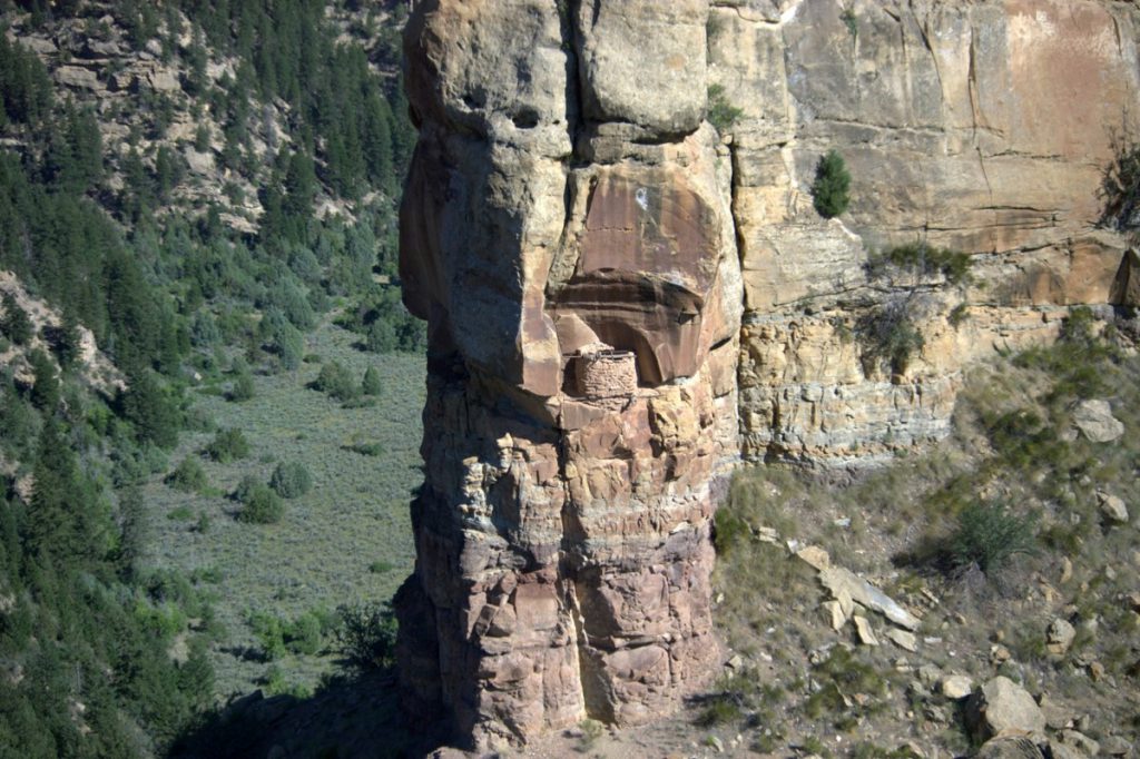
Figure 6: Cliff Granary in Range Creek Canyon
The instability of agriculture produces shortage and opportunities for inequality. Inequality is the breeding ground of power. In some places and times during Fremont history food was stored in granaries placed in the cliffs, in locations of difficult access. These have long intrigued visitors to the American Southwest. This image conjures notions of ostentatious inaccessibility. Fully visible from below, the food is in full view . . . but impossible to access without everyone knowing. Courtesy of Francois Gohier.
Fremont peoples lived during a time when climate was favorable to farming. Known as the Medieval Climatic Anomaly, it was a warm period with summer monsoon rainfall. It was also a balancing act. Farm production was different every year, with bunches of five to ten good years punctuated by an equal number of poor years, and sometimes longer spans of good and bad times. Each time people survived a drought or a cold stretch, populations surged, and people invested a bit more in their fields. This seemed to work and the Fremont culture grew. If the Fremont were so good at managing a fluctuating climate and a diverse, dynamic people and land, why did it ever end?
The world’s climate began a prolonged cooling trend and an erratic rainfall pattern in the 13th century ushering in the Little Ice Age that continued to the early 20th century. After centuries of farming the Fremont lifeway began to change even as the Fremont held on. The local abandonments that were once a routine part of Fremont place became final emigrations. A few people could fade into the wilderness and become foragers as they had on other occasions. But foraging could not support everyone. By the A.D. 1500s only a few farming outposts remained. Some of the Colorado Plateau Fremont who spoke an early Kiowa-Tanoan language migrated north and became the Kiowa originating as a historically known tribe near Yellowstone, and eventually ending up in the southern Plains. The western, Uto-Aztecan Fremont may have migrated south to join related language groups such as Hopi in northern Arizona. The Fremont did not simply give up on farming because of climate change; they were just one group among many in North America responding to change.
The historic tribes of Utah including the Ute, Southern Paiute, and Shoshoni (Goshute is a dialect of Shoshoni), speaking languages collectively known as Numic were also part of the landscape. By A.D. 1000, Numic foragers learned and borrowed pottery from the farmers and created their own versions long before the demise of farming. Thus, the living Utah tribes are also part of and descended from the Fremont legacy.
See Also:
Cole, Sally J. 2012 Legacy on Stone: Rock Art of the Colorado Plateau and Four Corners Region. Johnson Books, Boulder, Colorado.
Fowler, Don D. and Catherine S. Fowler (editors) 2008 The Great Basin: People and Place in Ancient Times. School for Advanced Research Press, Santa Fe, New Mexico.
Grayson, Donald K. 2011 The Great Basin A Natural Prehistory. University of California Press, Berkeley.
Jones, Kevin T. and Layne Miller 2020 Standing on the Walls of Time: Ancient Art of Utah’s Cliffs and Canyons. University of Utah Press, Salt Lake City.
Noble, David Grant (editor) 2014 Living the Ancient Southwest. School for Advanced Research Press, Santa Fe, New Mexico.
Simms, Steven R. 2008/2016 Ancient Peoples of the Great Basin and Colorado Plateau (with original artwork by Eric Carlson and Noel Carmack). Routledge, New York.
Simms, Steven R. and Francois Gohier 2010 Traces of Fremont: Society and Rock Art in Ancient Utah. University of Utah Press, Salt Lake City.
Spangler, Jerry D. 2013 Nine Mile Canyon: The Archaeological History of an American Treasure. University of Utah Press, Salt Lake City.
Spangler, Jerry D. and James M. Aton2018 The Crimson Cowboys: The Remarkable Odyssey of the 1931 Claflin-Emerson Expedition. University of Utah Press, Salt Lake City.

