A History of Utah’s American Indians, © 2000
“The White Mesa Utes,” pp. 225–63
Robert S. McPherson and Mary Jane Yazzie
Billy Mike, the oldest living resident of the White Mesa Ute community, sat comfortably and slowly ran his fingers through his silver hair. The thick glasses perched upon his nose served more as a token of past vision than as an aid to see today’s world. Blind in one eye, and with failing sight in the other, he moved about slowly with the assistance of a cane. His life of ninety-some-odd years had spanned a period of transition for the Ute people. At times, his mind wandered clearly over events from the past, while at other times his memory became clouded. But there was no doubt as he remembered his people’s association with the land before it had been divided and controlled by the white man. He recalled, “No one really owned the land. It was like it owned us–the Ute (Nuche) people.”1 This relationship of which he spoke–of land and people–went back, according to tribal accounts, to the beginning of time, when the gods played a part in establishing the Ute’s domain.
Following the creation of the world, the gods contained the people of the earth in a large sack. The Shin-au-av brothers, Pavits and Skaits, received the bag with the instructions to carry it unopened to the center of the world. However, curiosity overwhelmed Shin-au-av Skaits, who opened the bag and then watched many humans flee from its confines. Tav-woats, another god, saw what was happening, angrily resealed the bag, and took the remaining people to the only place left: the desert and mountains of the Four Corners region.2 There he released them to settle in the area to become the Paiutes and Southern Utes–known as Nuche, Nutc, or Nunts, and translated as “The People.” Various versions of this story exist; each band of Utes and Paiutes tells of how the sack was opened in their particular territory, thus creating the “homeland” of all the groups.3
Historic and anthropological sources paint a different picture. Based upon their studies, the Numic-speaking peoples entered the Four Corners area close to the time of its abandonment by the Anasazi, roughly between A.D. 1200 and 1300. Exactly when and where these Native Americans came from is still open to debate. Most scholars agree that the initial homeland of Uto-Aztecan speakers was in the area of Death Valley in southern California. Some 3–5,000 years ago this language family started to diversify into nine major groups known today. Numic speakers comprised one of these divisions, which includes the language spoken by today’s Utes and Paiutes. Fanning out from their central location, these two groups moved northeasterly; but they remained on the edge of the Great Basin until about 1,000 years ago, when they moved rapidly into the basin and eventually onto the neighboring Colorado Plateau. Their language became increasingly diversified as splits in groups occurred, one anthropologist suggesting that the Utes separated from the Southern Paiutes 400 years ago as they settled in the Four Corners region.4
Today, the two languages are still mutually intelligible. Southern Utes and Southern Paiutes recognize dialectical differences in speech, one Ute informant saying that the Paiutes’ language is more “clipped” or abbreviated and that the Paiutes accused the Utes of “talking fancy.” This goes along with the general pattern of the Southern Paiutes’ consideration of the Utes as their “fancy” cousins, who went off to the plains and learned “everything.”5
The archaeological and ethnographic record of Ute and Paiute entrance into the Four Corners area is vague. Campsites and material remains are difficult to find and differentiate from those left by earlier peoples because of the small amount of pottery, nondescript dwellings, and limited technology necessitated by a hunting-and-gathering lifestyle. The analysis is made even more difficult by the Utes’ practice of utilizing other peoples’ camps and material remains.6 Robert Euler, a noted Paiute historian, suggests that there were two migrations of Numic speakers into Nevada and Utah. The first one took place around the beginning of the Christian era, the second more than one thousand years later, around A.D. 1150, this last movement possibly causing the resident Anasazi to withdraw into larger, more defensible sites. At the same time, Paiute culture became quite stable, with few changes in lifestyle and technology until well into the late nineteenth century. Some archaeologists place the date of this entry later, during the 1300s.7
The San Juan Band Paiutes and Southern Utes were part of this eastward movement of people who entered present-day San Juan County. The effect the intrusion had on the Anasazi is questionable, but some authors suggest that the reason for the sudden expansion of Numic speakers into the Great Basin and onto the Colorado Plateau occurred because of severe droughts during the twelfth and thirteenth centuries. Some anthropologists believe that this first could have caused relocation within, then evacuation of, those areas by the agriculturally oriented puebloans. Numic speakers, better adapted to surviving the rigors of a desert environment, filled the occupation gaps left by the migrating Fremont and Anasazi cultures. In support of this theory, it is interesting to note that the Anasazi abandoned a well-developed community at Navajo Mountain by A.D. 1270, evidence suggesting not that the Paiutes forced a withdrawal but that they could have been present when it occurred.8
How Southern Utes and Paiutes view the Anasazi helps to partially support this contention. They call the Anasazi the muukwitsi, meaning “the dead,” and believe that the dead, their spirits, and spiders are interrelated. This then helps explain why spiders often haunt the ruins. Utes use the same name to refer to the Hopi, “Moqui” (pronounced Mawkwi, not Mokee)–a term applied only to this pueblo group and which seems to have entered general usage following the Dominguez-Escalante expedition of 1776 that depended heavily upon Numic speakers for guides. According to some Ute informants, there never was conflict with the Anasazi; among other things, they shared a language that could almost be understood. The Utes also tell how they would only see their neighbors sporadically because the Anasazi appeared “like phantoms and would be seen at a distance or be heard to scream, but would disappear into the pinyon when a Ute approached.”9
Some scholars argue that the Utes and Paiutes were not even in the region at this time (A.D. 1300). One explanation of migratory trends places Numic speakers in southwestern Utah some 430 years ago (about 1560), in southeastern Utah and southwestern Colorado 370 years ago, moving along the Rio Grande 330 years ago, and out on the Great Plains–their easternmost expansion–some 300 years ago.10 All of these dates are speculative, but few people would argue with the point that by the 1500s the Utes and Paiutes of San Juan County were in their general historic setting.
By the early 1600s, Spanish reports indicated that there were Utes living in northwestern Arizona, north of the Colorado and San Juan Rivers, and in eastern Colorado.11 Early accounts do not provide exact distinctions between different Numic speakers–the Utes, Paiutes, and Chemehuevi all being designated by the Spanish as “Yutas.” Today, however, a clearer understanding provides knowledge of the three bands that comprise the Southern Utes. Starting from the east there were the Muache, living in the Denver area; the Capote in the Sangre de Cristo Mountains of Colorado and south to Taos, New Mexico; and the Weenuche, who ranged from the Dolores River in the east to the Colorado River in the north and west to the San Juan River in the south.12 All of these groups were highly mobile and visited far into the Great Basin, throughout the Colorado Plateau, and onto the Great Plains.
Some confusion concerning names exists in the historic record. Anthropologists and historians have collectively lumped the three aforementioned bands together under the title of Southern Utes. To the Ute people in southeastern Utah and southwestern Colorado today, however, this title properly refers only to those living on the Southern Ute reservation headquartered in Ignacio, Colorado. In this chapter, this name will be used in the broader, collective sense. The Weenuche Band’s name also has been misrepresented. The literature concerning this group refers to them as the “Weeminuche,” with a variety of spellings–Wimonuntci, Weminutc, Guibisnuches, Guiguimuches, Wamenuches, and others–that has evolved over the period of time since white contact. It likely was introduced as an inside or intertribal joke that puns on a word associated with sexual activity. For whatever reason it was started, the use of the word has become entrenched among scholars but is not accepted by many of the Ute people it refers to. Thus, the term Weenuche, describing the band of Southern Utes who inhabit southeastern Utah, is used here.13
The second group of Numic speakers in this area is the San Juan Band Paiute. Historically, they have been the least understood of an already amorphous group. Southern Paiute territory centered in southwestern Utah and Nevada, with its most eastward extension pushing into the Monument Valley region of the Utah-Arizona border. Sixteen identifiable bands comprise the Paiute tribe, with the San Juan Band being the only group to occupy lands south and east of the Colorado River. Perhaps this is why their name has been translated as “people being over on the opposite side,” or as the “San Juan River People.”14
William Palmer, during his interviews with Paiutes around Cedar City in 1928, found those Paiutes had only a slight knowledge of groups existing in southeastern Utah, his informants indicating that these people were called “‘Nau-wana-tats,’ which to the Pahutes [sic] means fighters or wrestlers. If there is a tribe of this name, the Indians interviewed think they are in the San Juan Country.”15 This vagueness underscores the fact that there was little cohesiveness between certain bands and that the area of southeastern Utah was peripheral to major Paiute activity. The San Juan Band may be subdivided into the Tatsiwinunts, who ranged over the area between Tuba City and Navajo Creek, and the Kai-boka-dottawip-nunts in the Navajo Mountain area.16
By 1935, Palmer’s interest in this elusive group had peaked. Accompanied by a Paiute translator, he visited Allen Canyon, home of the allotted Ute/Paiute faction in southeastern Utah, to determine exactly how “Paiute” and how “Ute” these people were. He reported that he was “surprised, almost amazed, to find this long isolated band speaking more nearly pure Pahute than some of the clans that attend the tribal saparovan [council] every year and do much visiting back and forth every summer.”17 The sacred stories, told by an esteemed raconteur, or Narraguinip, were also identical to those of other Paiute bands.
Today, family groups such as the Dutchies, Cantsees, Lehis, and Poseys have Paiute roots that extend back to the Douglas Mesa–Monument Valley–Navajo Mountain area, while other families such as the Ketchums, Mikes, Hatches, and Eyetoos are more closely related to the Weenuche or Ute Mountain Utes living at Towaoc. Until the mid- 1920s, the three main permanent camps of Numic speakers in southeastern Utah were at Navajo Mountain (Paiute), Allen Canyon (predominantly Paiute, but with a significant mix of Ute), and Montezuma Canyon (predominantly Weenuche Ute).18 This point should not be stressed too heavily, however, since a great deal of intermarriage, trade, and social interaction characterized all three groups.
The major distinction between the Utes and Paiutes living in this area was cultural, not linguistic, affected by the environment and accompanying technology. There was no clear line of demarcation. Paiutes operated in family groups, and, when resources allowed, came together as bands. They hunted and gathered in an austere desert land, had no centralized chieftain, no collective religious practices, and no common goal or practice (other than survival) that would unite the different groups. The Utes started from the same cultural roots, but with the utilization of the horse in the mid-to-late 1600s and the development of aspects of Plains Indian culture those groups farthest east started to change. The Weenuche, farthest to the west, were the last to adopt these practices from their fellow tribal members. For reasons of simplicity, this amalgamation of groups will be referred to here generally as Utes.
The interaction with the land by these people spoke of deep cultural ties. Though they have not been as well documented as some historic groups, the Utes placed names and endowed the land and its creatures with significance. General descriptive names of places in southeastern Utah include Water Canyon or River-Flowing-from-the-Sunrise (San Juan River), Sagebrush Canyon or Crows Canyon (Montezuma Canyon), Slick Rock Mound (Comb Ridge), Two Rocks Canyon (Cow Canyon), Bitter Root Mountain (Sleeping Ute Mountain), and Where-the-Sun-Sets-Last (Mount Tukuhnikivats in the La Sal Mountains).19 Mancos (Jim) Mesa and the Spanish Mossback mesas were said to have been “fortified strongholds” for the Utes, who in time of troubles would barricade themselves within the steep, rocky slopes and walls of these mesas.20 Blue Mountain, Standing-Alone-Mountain (Navajo Mountain), and the La Sals have all been identified as Ute places of worship.
There are also stories that teach values about the land. For instance, Sleeping Ute Mountain near Cortez, Colorado, is said to be one of seven giants who protected the Utes from other tribes’ gods during the times of the myths. He then grew tired, fell into a deep sleep, and there will remain until he is again needed. The mountain is said to be inhabited by supernatural beings who are appealed to through prayer and ceremony.
There are many other teachings from the Utes that look at the land through religious or philosophical eyes. Tales are tinged with supernatural and mystical experiences that imbue the Four Corners region with a power and sense of divine meaning pre-dating contemporary humans. For instance, in the time of the myths it is said that the chief of all the Utes lost his wife and did not know where to look for her. Tav-woats, a supernatural being, answered his prayers by taking the man to the land of the dead to locate her. The god rolled a great magical ball of fire before them, cutting the earth and its mountains, creating a path upon which the two could walk. The husband arrived in the land of the dead, saw how happy his wife was, and returned to the living after being cautioned that he should not walk upon this trail again. Tav-woats ensured that humans kept this law by forming a river in the trail–known today as the Colorado River and the Grand Canyon.21
Another story tells of how the gods gave the Indians fire by placing it in every visible form. When a tree or grass burns, it is the fire coming out, and when sparks fly from a rock, it is releasing the power trapped long ago. Yet another tale tells how pieces of petrified wood are the remains of a fight between the sun and another supernatural being. The two battled on the ground and in the air; their lightning arrow shafts turned into petrified wood, while the missiles hurled by the sun remain as cobblestones. Since the rainbow was the weapon used against the sun, it is now found on the other side of the sky, away from the fiery orb. In another legend, a bear tells the Utes that he is heading to the Bears Ears country because that is where he will find “bull-grass, strawberries and good eating.”22 Thus, physical forms upon the land often held a deep mythological significance for the Utes.
Spiritual beings also reside on the mesas and in the canyons, where they either hide or show deer and elk to hunters who have prepared themselves through ritual. If these little people are seen, the individual must leave a blanket, food, or some other useful object and then depart. By saying nothing about this incident, the person is guaranteed good fortune in the future. Utes also held healing rites in what is now called Babylon Pasture, Peavine Canyon, and on the Bears Ears because of the supernatural power invested in the landscape.23
The People, as part of the larger ecosystem, blended the religious with the pragmatic side of survival in an austere land. Different family groups would join together for hunting and gathering. Each of these bands would have a leader, selected as a man who made wise decisions in knowing where to obtain food and how to keep the group out of trouble. The size of these groups would vary from one to ten families; but, as the People lost more and more land to white encroachment, they were forced together into smaller concentrations, primarily in Montezuma and Allen Canyons.
Each of these bands often would have a spiritual leader who understood the supernatural powers associated with the land and how to best appeal to them. He would go to these “power points” during the season of use and on behalf of his group would pray, leave an offering, and ask for help. Individual prayer by the general members of the band was also practiced, but not at the “power point” used by the medicine man.24 Different types of spirits were believed to live in caves, rocks, springs, rivers, mountains, and other places and could provide help or harm depending upon how they are treated. These same powers as well as those associated with animals, plants, and natural phenomena such as whirlwinds, the moon, and lightning may also “transmit the high voltage of supernatural power to humble practitioners or doctors.”25 The location of specific power sites is not general knowledge and should be discussed only with those who have a need to know.
The life of a nineteenth-century Ute, before intense white contact forced drastic changes, was tied closely to the rhythms of nature. The People followed a seasonal pattern of migration that was carefully bound to the plants and animals ready for harvest in an area. Not surprisingly, water and grass played a dominant role. The people selected campsites based upon the availability of springs, streams, and rivers for drinking water, grass for livestock, firewood and trees for shelter, and lower elevations to avoid the deep snows of winter. Just as the deer moved down from the higher elevations in the late fall, the People would follow the same pattern, descending to valley or canyon floors where shelter and more abundant food were available.
This natural cycle was incorporated into the descriptive names given to the seasons of the year. For example, fall was called “leaves turning yellow,” winter “heavy snow” or “hard times month,” spring “snow melting’ and summer “leaves coming out” or “much warmer for growing things.” Three spring months had specific titles: March, “warm days beginning”; April, “green grass appearing”; and May, “mother of the two preceding months.” The People started their move back to the mountains at the time “when the doves sound soft.”26
The Utes established their winter camps in locations such as Montezuma Canyon, with its neighboring Cross, Squaw, and Benow Canyons; Dry Valley; Harts Draw; Beef Basin; Westwater and Cottonwood Canyons; Butler Wash; White and Douglas Mesas; and along the San Juan River–especially in the vicinity of Bluff and Sand Island. As the weather warmed and the grasses appeared, streams like La Sal, Deer, Coyote, Two Mile, Hop, Geyser, Taylor, and Beaver on the La Sal Mountains and Spring, North and South Montezuma, Cottonwood, Recapture, and Indian Creeks poured off Blue Mountain. Numerous springs such as Dodge, Piute, and Peters also invited the Utes to scatter and camp as they searched for food.27 Favorite areas to plant small garden plots in corn, beans, squash, and melons were in Montezuma and Allen Canyons, Indian Creek, Paiute Farms, and Paiute Canyon.
Deer played the most important part in the Ute economy. Besides providing food, the deer supplied hides to be fashioned into clothing or traded with other tribes, especially the Navajo. The People prepared a deerskin by first stitching it on a willow hoop, scraping off the fat and flesh with a serrated bone scraper fashioned from a deer leg, rubbing deer brains into the hide, rinsing it in water, re-stretching it, and, if desired, rubbing it with either a yellow root or smoking it over a fire to soften it.28
Favorite hunting places for deer and other large animals were Elk Ridge and the La Sal, Blue, Navajo, and Sleeping Ute Mountains, while pronghorn were hunted in the Dry Valley area. Elk, desert bighorn and mountain sheep, wild turkey, rabbits, badger, beaver, bear, and fish added to the diet. Women gathered many of the edible wild plants, including pine nuts, chokecherries, yucca fruit, Indian ricegrass, wild onions and potatoes, sunflower seeds, bullrushes, serviceberries, and raspberries.29
Homes reflected the needs of a mobile hunting-and-gathering society. Tepees, and later canvas tents, served as the winter home of the Utes. Construction included a four-pole base frame with ten poles total, the dwelling standing ten feet high with an average diameter of fourteen feet. Elk or deer hides stitched together, and later canvas or muslin covers, were wrapped around the frame and fastened in the front with skewers. Brush wickiups, based on the four-pole pattern or with poles leaned against a tree, provided shelter in the summer time.30
Exposure to sickness was an ever-present possibility for the People, whose health practices included as much religious and spiritual curing as physical, tangible medicine. Ute beliefs, for instance, centered around the shaman, usually a man, who received his healing power either through a charm obtained from an older medicine man or through dreams provided by supernatural beings. The dreams gave secret information concerning power within animals, plants, and natural elements that the shaman could invoke for good. He often learned these healing rites through repeated dreams received during the years of puberty. These supernatural teachings could not be denied, but they also could not be divulged, charging him with a lifelong responsibility of service.
A typical Ute healing ceremony consisted of the medicine man using the information about paraphernalia or other measures he received in his dream to chant, pray, suck out, and otherwise exorcise the evil afflicting the sick person. Usually he performed at night, either in his or the patient’s home. Stripped to the waist, the medicine man used sleight of hand, dancing feathers, and personal attacks on the illness. Inside the shaman was a small being, or powa’a, that directed the use of power and swallowed the sickness when it was removed by sucking from the patient. If the powa’a was misused or became angry it could turn on the practitioner, calling for blood and causing illness or witchcraft.31
Herbs and plants also played an important role in healing. Ute patients drank tea brewed from sagebrush leaves; a sore throat was treated by boiling pinyon sap with grease and then applying it externally on the neck; the roots and flowers of sand puff remedied stomach and bowel problems; spearmint leaves cured an upset stomach; and gum plant served as a cough syrup. Non-plant remedies included putting breast milk on a nursing baby’s sore eyes, sugar on large cuts to stop bleeding, skunk grease on chapped hands and feet, and horse urine on pustules that broke and caused itching. Tobacco was used as a pain reliever for a decayed tooth. Later, a sore throat was swabbed with baking powder.32 In a world dominated by spirits and the possibility of physical harm, the Utes fortified themselves against the trials of life.
One aspect of the social and religious life of the People is the Bear Dance, traditionally performed in the spring. Symbolically, it was a ceremony taught by a bear to the Utes to help the animals awaken from hibernation and to strengthen the relationship between man and this very powerful creature. The brush circle in which the dance is performed is called “cave of sticks” and is constructed of cottonwood limbs, juniper boughs, and sagebrush. The structure opens to the east and represents a bear’s den, while the rasping sound of a wooden stick dragged across another serrated stick represents the noises of a bear.
A Ute Bear Dance being performed on the Uintah-Ouray Reservation in 1924
The Bear Dance is believed to be the only dance to have originated specifically with the Utes. Bluff, Montezuma Canyon, and Allen Canyon were the three sites where the dance was traditionally held in southeastern Utah. The gathering in the spring was a social event where young people could meet, marriage partners be selected, and elders discuss hunting and gathering plans of the various groups. The rebirth and fertility of nature were themes echoed throughout the feasting and dancing. Once the activity ended, the People dispersed to their individual group locations to hunt and gather. Today, the Bear Dance is held in the fall at White Mesa in order to accommodate dances and ceremonies to Ute people in other locations.
An important ceremony practiced by the Ute Mountain Utes to which the People of southeastern Utah have been invited and in which they have participated is the Sun Dance. Although not of Ute origin, this ceremony embodies many important teachings derived from supernatural beings. As with the Bear Dance, it is held in a cottonwood-and-brush enclosure that opens to the east. In the center is a large, erect pole with four scarves–one red to represent the earth, one yellow for the sun, white for daylight, and black for darkness–all of which are offerings to the four directions. Before dancing, men go to a sacred spot where they fast for four days to determine if the gods have selected them. If a man dreams three times about participating, it is considered that he has a special purpose in life to fulfill and will be attended by his guardian spirit. The power derived from the performance of the dance ensures that food will be plentiful, the sick and afflicted will be healed, and that supernatural beings are pleased with the sacrifice. Although this ceremony was introduced to the Ute Mountain Utes at a fairly late date–between 1890 and 1910–it has held deeply significant religious values for the People.33
Even in this brief survey of Ute economic, social, and religious practices, one sees clearly their dependence upon, and interconnectedness with, the land. Because of the advancing white frontier, however, control of this key factor in their life could not be maintained indefinitely. The history of the Utes in southeastern Utah attests to an initially friendly relationship with whites that changed as ownership and use of the land became increasingly challenged. Then, conflict against overwhelming odds became a way of life for the embattled Utes. Loss of the land resulted in an impoverished and embittered people. To understand this process, one must return to the earliest recorded contacts between the People and the Spanish in the Four Corners region.
In 1712 the governor of New Mexico, Juan Ignacio Flores Mogollon, forbade Spanish traders from venturing into Ute lands, which lay generally in northern New Mexico and in Colorado and Utah.34 Not until June 1765 did Governor Tomas Velez de Cachupin grant special permission for Juan Maria Antonio Rivera to travel into Indian country. How many others had preceded Rivera is unknown, but part of the decision to bend official policy sprang from the governor’s wish to find a crossing of the Colorado River, to identify the local Indian groups en route, and to determine their attitude toward the Spanish. Another reason was to discover if there was truth to the rumor that silver deposits existed in the area. This seemed possible, since a Ute named Wolfskin from that region had appeared in Abiquiu carrying a small silver ingot. More precious metals might be found, and so Rivera, in the guise of a trader with a small expedition, set out in search of mineral wealth and a trail.
Following old Indian paths, Rivera and his party arrived at the Los Pinos River in Colorado, where he found an adobe retort used to reduce the impurities in gold. Rivera took some of the bricks with him as proof, then sent four Spaniards and a Ute guide to locate Wolfskin. The party traveled from the Dolores River to Cross Canyon, then down an old Ute trail in Montezuma Canyon to the San Juan River. There they met a band of “wild Payuchis” living in ten lodges on the bank near present-day Montezuma Creek. One of the band jumped into the water and waded out to midstream where he used sign language to ascertain the Spaniards’ intent. The groups established peaceful relations, and three days later the Ute leader Chino accompanied the explorers back to the main camp on the Dolores. He said that Wolfskin had recently left for his home on the La Plata River, and cautioned that the heat and lack of water would make the trip to the Colorado River in July dangerous for the Spaniards. However, he said, if they would return in the fall, he would guide them to their destination.
Rivera, happy with his discovery, went back to Santa Fe, received permission and additional instructions to find a ford of the Rio del Tizon (Colorado River), outfitted another group, and returned by a more direct route to the Dolores River. From there, the party crossed into Utah northeast of Monticello on October 6, proceeded to the base of the La Sal Mountains, then moved to Spanish Valley and the present site of Moab. The recent discovery of Rivera’s detailed journal indicates that the Utes did all they could to discourage and lead astray the expedition. The Ute guide took them into the rough country of Indian Creek, Harts Draw, and part of present-day Canyonlands National Park before another Ute led them on a more direct route. The party eventually took a high trail on the western slopes of the La Sals before dropping down into Castle Creek and finding a crossing place on the Colorado River.35
Once he found a suitable ford, Rivera carved a cross and the words “Viva Jesus” in a cottonwood tree. His Ute guide warned that the party would now travel through lands inhabited by “child eaters,” “strawheads” (so named because of their hair), and “stone people.” With the promise of winter and troubles ahead, Rivera returned to Santa Fe in fourteen days’ time. He left behind his cross to assert Spanish rights, while his expeditions set the stage for the next act in the drama, the Dominguez–Escalante expedition, played out eleven years later.36
There were undoubtedly unofficial expeditions to this area, such as the one of Pedro Mora, Gregorio Sandoval, and Andres Muniz, who reported seeing Rivera’s cross in 1775; but these excursions are lost to history. Muniz, however, served as a guide the next year for Fray Francisco Atanasio Dominguez, Fray Silvestre Velez de Escalante, and seven other men as they wound their way through western Colorado in search of a feasible trail from Santa Fe to Monterey, California. The padres’ account of the Indians living on or in southeastern Utah is informative. They encountered Utes who warned them about running into a Comanche war party and being killed, but the fathers replied that God would protect them. They also obtained some guides by paying each a blanket, knife, and beads to lead them to the north. One of the Utes overindulged and became so sick that he accused the Spaniards of poisoning him, until he eased his discomfort through vomiting. Other Utes willingly sold food and listened to the Catholic fathers’ preaching, but often they tried to impede the journey to the north. Later, the fathers learned that some of their companions were telling the Indians to do this because they did not want to go farther. This was to no avail, as the expedition moved on as far north as Utah Valley.37
As Dominguez and Escalante continued down the western side of present-day Utah, they once again neared southeastern Utah and gave a description of the Indians they encountered, this time Paiutes, some of whom probably belonged to the San Juan Band. The fathers noticed how reticent these Indians were to approach them, no doubt in part because of the slave raiding and intertribal warfare that dominated their relations with other Indian groups. The Paiutes were happy to learn through an interpreter that since their enemies–the Navajos, Comanches, and Apaches–had not been baptized, they could not enter heaven and would “burn forever like wood in the fire.”38
The fathers made special note of a group of Paiutes, whom they called the “Payuchi Yutas,” east of the Colorado River. They were members of the San Juan Band Paiutes, who spoke the same language as the neighboring Paiute groups and the Utes to the east. The padres used some of their trails, reporting that they were built up with “loose stones and sticks.”39 Thus, Dominguez and Escalante were the first to provide an accurate ethnographic report of some of these early inhabitants.
The peaceful intentions of Dominguez and Escalante did little for those interested in economic gain. For instance, Muniz, who initially guided the group, smuggled trade goods along, acting expressly against the fathers’ wishes. He and his brother had spent time–three to four months in some instances–trading among the Indians of the Four Corners region.40 Such expeditions, exchanging furs, horses, guns, and slaves, caused constant consternation for the government trying to regulate Indian relations. In 1778, officials issued an edict to stem the flow of unlicensed trading activity in the borderlands. Ten men and two Indians stood trial in Abiquiu during 1783; two years later, several others were in similar circumstances for trading “in the interior of the country of the Utes in violation of repeated edicts.”41 Again, in 1812, officials passed a law to prohibit buying slaves from the Utes, and, not surprisingly, a year later seven men under Mauricio Arze and Largos Garcia stood before the judge for slave trading in Utah Valley.42 No doubt many of these expeditions–either coming or going–passed through the borders of San Juan County.
Utes, Navajos, and Spaniards continued their hostilities right through to the time of Spanish withdrawal from the American Southwest in 1821. Generally, these relations were characterized by the Spanish currying the favor of the Utes in order to use them against the Navajos. However, by the time the Mexican government faced the problem of controlling the Indians in its territory (1821–48), the Navajos had formed a friendly alliance with the Utes, much to the dismay of the settlers of New Mexico.
Reports filtered in to Santa Fe of Navajos and Utes working together to steal horses, forming alliances for slave raiding, living together in the La Plata and Sleeping Ute Mountains, and renewing friendships. Later, however, animosity again erupted.43
Traffic into the region built upon prior exploration, creating by 1830 a 1,200-mile route between Santa Fe and Los Angeles known as the Old Spanish Trail. Thanks to the efforts of Rivera, Dominguez-Escalante, and other less-publicized groups, this horse-and-pack-mule trail connected the interior of New Mexico with the Pacific Ocean while bypassing a section of Arizona noted for hostile Indians. Southeastern Utah hosted part of one branch of the route. It crossed the present-day state boundary at Ucolo near Piute Spring, dropped into Dry Valley, then generally followed the path of today’s Highway 163 through La Sal Junction, past Kane Springs, down Spanish Valley, into Moab, and across the Colorado River to the Green River near the present town of that name. From there the trail headed generally west through Salina Canyon, out to the Sevier River, south to Richfield and Circleville, and then dipped into extreme northwestern Arizona and southern Nevada.44
One of the major functions of the Spanish Trail was to expedite trade, the northerly route into central Utah being the most practical. Indeed, slave and horse trading boomed during the Mexican period. Exchange of human captives and other commodities along the trail by the Utes, Navajos, and Paiutes reached an apex during the 1830s and 1840s, then declined in the 1850s. New Mexican traders were the foundation upon which this slave, gun, and horse trade was built. Entering the San Juan region in caravans as large as 300 men and “dressed in every variety of costume, from the embroidered jacket of the wealthy Californian … to the scanty habiliments of the skin-clad Indians,” the traders sought out women and children to sell in New Mexico and to exchange later for horses and blankets along the trail or in California. As much as $200 might be paid for a young girl who could be trained as a domestic, while boys were worth only half that much.45
Starting in the mid-1850s, the fragile Ute-Navajo alliance started to splinter beyond repair. At the same time, Mormons in southwestern Utah were feeling the effects of the attempted invasion of Salt Lake City by federal troops under Colonel Albert Sidney Johnston in 1857–58. The Mormons, fearing the worst, encouraged the uniting of Navajos, Utes, and Paiutes to serve as auxiliaries in their militia–the Nauvoo Legion. Some Utes attended meetings with Brigham Young in Salt Lake City and then sent emissaries to the Navajos, encouraging that a peace conference be held. One Ute appeared at Fort Defiance with a certificate of membership and baptism into the LDS church, alarming government authorities with this tampering in Indian affairs. The Mormons scheduled a large meeting of Paiutes, Utes, and Navajos in the Navajo Mountain area, at which time the settlers reportedly handed out guns and ammunition to them.46
The effects of these rumors were twofold. First, the Utes received increased annuities from the government as bribes to keep them peacefully tied to their agency. Second, it alerted agents and military authorities to new concerns in the tangled web of conflict between the Navajos, Utes, Mexicans, and Anglo peoples.
However, the reality of a Ute-Navajo alliance faded. By the summer of 1858 the Utes were operating in large numbers against their Indian neighbors in the heart of Navajo territory. The federal government, anxious to gain control over the Navajos, skillfully used the Utes to help in this process of subjugation. The military encouraged forays against the Ute’s traditional enemy, saying that the Utes “appear to have inspired the Navajos with a dread not to be gotten over.”47
On a more local level and as part of the plan to force the Navajos to surrender, military commanders encouraged general raids by Utes, Mexicans, Jicarilla Apaches, and Pueblo peoples against their enemy. In General Dixon Miles’s words, “Let loose on these Indians all the surrounding tribes and inhabitants, particularly the Utahs and Mexicans, the two they seem to dread the most.”48 Soldiers reported finding large trails made by herds of Ute-captured horses headed north, while Utes started scouting for the army as “spies and guides.”49
Working with Kit Carson, Colonel Thomas T. Fauntleroy, a former Ute agent to the Weenuche in Abiquiu, suggested that a band of 300–400 Utes could augment the six to eight companies of Mexican volunteers and spearhead the thrust into Navajo territory. Nothing would be more effective than to use them to ferret out the enemy from their camps in the deep recesses of the Chuska/Tunicha Mountains, Canyon de Chelly, and areas as far west as the Little Colorado. Indeed, field reports indicated that camps in the Navajo Mountain region and Carrizo Mountains in Arizona were already abandoned.
Carson guaranteed the eagerness of the Utes, “the best riflemen in the world,” to wage war. He continued,
- I desire that I may be allowed to employ them, as they do not require pay as soldiers, but only to be supplied for a short time with provisions, until they can get well into the Indian country. I cannot but recommend this plan as it will at once have the effect to get the cooperation of a most valuable force, and at the same time employ these restless people, who otherwise must foray upon our own settlements.50
This was a perfect solution that gave the Utes something to do while providing for their welfare at the expense of the Navajos. They also rendered a service that was difficult, at best, for the conventional military.
As Ute pressures increased during the 1 860s, the Navajos intensified their own use of Paiutes. Beyond the more mundane cooperation in daily life, the Paiutes provided a lookout service to protect Navajo camps. For instance, K’aayelii lived in the Bears Ears area, where he established a settlement of five or six hogans. To prevent surprise attacks, he posted Paiutes along the various approaches to his camp. This was also done in the Navajo Mountain area, where the Navajos were said to be “hiding behind” the Paiutes.51
Perhaps the most dramatic proof of Ute, Paiute, and Navajo cooperation occurred in September 1866 when a group of Capote and Weenuche Utes and a few Mexicans met to plan a trap for some Navajos who had avoided capture and were living in northern Arizona. They intended to invite the Navajos to live nearby, but when they arrived the Utes would kill the men, enslave the women and children, and capture the livestock. However, upon hearing this plan, Cabeza Blanca, a Weenuche leader, disagreed with the others, saying that he had friends among those Navajos whom he did not want to have killed. A fight ensued during which the Capotes killed Cabeza Blanca and then fled to Tierra Amarilla for protection. After exacting revenge, the Weenuche, according to a government report, “then left, joining as is supposed the Wymin and Pah Utes who had made friends with the Navajos in the meantime. The whole party of Wymin, Pah Utes, and Navajos then left that region and went to the neighborhood of Rio Dolores, Sierra Salir [La Sal Mountains], and Sierra Orejas [Bears Ears] .”52
In 1868, with the official end of hostilities and the return of captive Navajos from Fort Sumner, a whole new set of problems confronted the Utes residing in the Four Corners area. As Civil War veterans poured into the West, mining strikes became more frequent and numerous agricultural settlements were established. The whites demanded that Indians be kept on a reservation far from civilization. The Utes refused; they wanted little to do with a livelihood primarily concerned with agriculture. They enjoyed their freedom, insisting they had performed a good service for the Americans and so should remain unmolested.
Western Colorado had always been Ute, and so the people of New Mexico urged they be expelled to this region and the Abiquiu agency be closed to the Capote and Weenuche bands. It was believed that the Muache at the Cimarron agency, “with a little management,” could also be persuaded to leave. However, underlying the Utes’ hesitance were religious beliefs. Diego Archuleta, an unsympathetic agent, explained, “These savages are possessed of the most heathenish superstitions against abandoning those places where the remains of their ancestors lie…[and] they consider their reduction to reservations as a species of slavery.”53
Ute Agent W.F.M. Amy even encouraged the taking of Ute lands by stating in his annual report of 1867 that several thousand white families could homestead in the area north and east of the Animas River. By establishing a reservation, the mining and agricultural resources of the region would be opened for development, and this could be “done at a comparatively small expense, for it is cheaper to dispose of these Indians in this way than to fight and exterminate them.”54 Amy felt he could move the Capote and Weenuche onto a reservation on the San Juan River for $49,500. Within a year he had the paperwork completed.
At the same time that the Navajos received their reservation on the New Mexico–Arizona border, well below the San Juan River, the Utes also obtained a reservation. On August 19, 1868, Amy met with Weenuche and Capote leaders at Pagosa Springs in southwestern Colorado. The Indians outlined what they considered desirable reservation boundaries, given the already deteriorating circumstances on their lands to the east. They wanted to be guaranteed the territory encompassed by the Grand (Colorado) and Green Rivers to the north, the headwaters of the San Juan River on the east, the Colorado River on the west, and the Navajo country to the south.55
The Utes begrudgingly signed a treaty in Washington, D.C., that removed them to Colorado, though the Abiquiu and Cimarron agencies did not close until 1878 when the two new agencies in Colorado were completed. What the Utes received, however, was far different than what they had asked for–all of their territory was in Colorado. Although the reservation initially included much of the upper San Juan River area, the lower San Juan in Utah remained a fringe area that no one seemed too excited about in 1868. The Four Corners area was peripheral to the white mining and settlement activities of the 1860s, staying in a twilight zone of general use by some Navajos and Paiutes but dominated by the Weenuche Utes.
This relative isolation soon changed. By the early 1 870s, the estimated 700 to 1,000 Weenuche still lived by “the chase” and came to their Abiquiu agency in New Mexico only for gunpowder and lead. According to their agent, they were “very much attached to the localities” in which they lived and were characterized as “excellent shots … great friends of our government.., and are… reasonable and docile.”56 But they also needed to protect what they had. In 1871 the agent noted that other groups of Utes prior to that time had feared entering Weenuche country but now were overcoming this attitude and hunting in Weenuche territory, thus increasing the pressure on available resources.57
In 1873 the Utes signed another treaty, the Brunot Agreement, that removed massive chunks of land from their reservation, so much that by 1880 and one more treaty comparatively little remained of their holdings. Using Colorado as an example, this meant that from their original holdings of 56 million acres, the first treaty promised only 18 million acres (about 9 million to the Southern Ute and a similar amount to the Ute Mountain Ute or Weenuche). By 1934 both of these groups had their holdings reduced by various means to only 553,600 acres.58
Of even greater concern was the influx of white settlers, who, starting in 1878, scouted out farms and livestock ranges along the San Juan River and in McElmo Canyon, a natural thoroughfare leading from Colorado into Utah. The Weenuche Utes and Paiutes of San Juan County became increasingly uneasy about this invasion from the east, especially when Mormons added to the growing cluster of regional settlements in 1880. Add to this the probing tentacles of Navajo expansion from the south, and friction over resources became inevitable and continuous.
Southeastern Utah north of the San Juan River was public domain that the Weenuche Band of the Southern Utes considered to be theirs. Small bands of Navajos either visited or took up residence there during the 1860s, ?70s, and ?80s, but it was not until the mid-1880s, as the Navajo reservation expanded north, that larger populations entered to stay. When the Southern Utes and Navajos each received their reservations in 1868, one of the treaty stipulations specified that the Indians would “retain the right to hunt on any unoccupied lands contiguous to the reservation, so long as the large game may range thereon in such numbers as to justify the chase.”59 The Indians took advantage of this opportunity since neither group could survive solely on their livestock or agricultural produce. The Utes’ reservation by the 1880s had shrunk from roughly one-third of Colorado to a land area only fifteen miles wide and 110 miles long in some of the most desolate territory in the southwestern corner of the state. Few alternatives, other than off-reservation hunting, allowed the Native Americans the opportunity to obtain wild game.
One of the greatest threats to Ute resources came in the guise of cattle companies searching for free-use public lands for grazing. By the 1880s four major outfits ranged thousands of cattle on the grass and brush of San Juan canyon country. The two most important were those of Edmund and Harold Carlisle (called the Kansas and New Mexico Land and Cattle Company) and the L.C. outfit, located on Recapture and Verdure Creeks at the head of Montezuma Canyon. The size of these companies was considerable, the latter alone selling 22,000 head between 1891 and 1893.60 Herds of this magnitude changed the quality of the environment within just a few years’ time, increasing the conflict between Indians and whites. Although many of these cattle companies would rise to meteoric heights only to fail, there always was another group to step in to keep the cattle business alive.
When bands of Navajos and Utes left their reservations, they quickly encountered the stock of the cattlemen, who grazed their herds in the same places and at the same time of year as the deer. Grass, forbs, brush, and water were most plentiful on the mountains, and so it was not long before Indian agents received some blistering correspondence spelling out Native American activities. Edmund Carlisle, co-owner of the huge Kansas and New Mexico Land and Cattle Company, contacted the Southern Ute agent, reporting that the Indians were off the reservation with written permission from a local trader, that they had been firing the timberlands on the south side of Blue Mountain in San Juan County, Utah, causing severe damage, and that they not only had killed deer but also cattle. The livestock owners wanted soldiers sent to control the Utes and “other Indians.” More letters followed, indicating that this hunting group, comprised of some forty Southern Utes and a similar number of Navajos, was heading west to continue its hunt. Cowboys and white citizens alike threatened to form groups to attack the Indians, and, though no organized posse moved against them, there were individual encounters that resulted in a handful of people being killed on both sides.61
The next few years showed little improvement in the situation. In 1885 one man complained that half of the Southern Utes were off the reservation, burning grass and killing cattle because the Indians suffered from hunger, and that he dared not hunt for fear of being killed. Whites were not the only ones concerned. The Southern Utes from Colorado entered southeastern Utah with the express purpose of rounding up the deer like cattle and either killing them or driving them closer to their reservation. The Southern Utes and Paiutes already living in Utah were greatly angered by this attempt to remove game from their territory. The first of three annual hunts started in 1884, with an estimated 300 Indians killing or wounding deer by the hundreds and drifting thousands of others to the south and east of the La Sal Mountains.
By 1889 events had reached a boiling point. To settle conflicting reports, the U.S. military sent Second Lieutenant George Williams to Blue Mountain in December of that year. Although he saw no Indian hunters, he estimated that 200 to 300 Navajos and Utes had been hunting there but had returned to their reservations. He claimed that the Indians had “killed a good many deer as is shown by the number of hides they have sold to the trader.”62 The twelve white families living in Monticello at the base of the mountain reported that the Utes hunted for hides and meat, the Navajos primarily for hides. Many of the cowmen complained that with all of the Indians chasing through the woods, the livestock had grown more wild and harder to herd.
Williams also reported a problem with too many Indian groups hunting in the same territory. Navajos and Utes did not traditionally get along well with each other, and rubbing shoulders while armed in the isolation of the mountains could lead to explosive situations. Although no conflict actually erupted between the two tribes, this was not true of the Colorado and Utah Ute/Paiute bands. One person known to history as Hatch, from Utah, got into an argument with a man named Cowboy from Colorado while camped at Peters Spring near Monticello. Apparently the friction evolved over the killing and driving away of the deer herds. Cowboy killed Hatch and the bands separated; but, when they met again in town, the men dismounted and prepared for a shoot-out amid the settlers’ cabins and stores. Cooler heads prevailed, however, and both groups went their way, leaving vivid evidence of the importance of the deer herds to all Indian peoples.63
In the 1890s increased pressures on the Utes by their agents and an expanding Navajo population started to change the complexion of events. The Ute agent took the opportunity to show that his charges were really on the reservation and that much of the hunting was being done by Navajos but that the blame was still placed on the Utes. He even sent a letter to the Navajos and their agent saying that the Utes and their white neighbors complained about Navajos killing game both on the reservation and to its north. He ordered them to leave with all of their livestock and no longer make the Utes’ land their headquarters for killing cattle and hunting deer.64
The Utes needed some type of economy to survive, yet they did not have the same economic base of agriculture and livestock (sheep, goats, and cattle) that allowed the Navajos to prosper. Hunting as a way of life was becoming totally impractical. Beadwork and baskets, famous crafts of the Utes, were not as stylish as Navajo rugs and never moved beyond a very local economy that produced little revenue.
Different Ute groups in San Juan County under the leadership of Red Jacket, Narraguinip, Mariano, Bridger Jack, Polk, Johnny Benow, and Posey reacted to the general deterioration of lifestyle that occurred during this and later time periods. Many of these fragmentary bands either moved to their reservation in Colorado or coalesced into what would be recognized by the early 1900s as the Montezuma Canyon and the Allen Canyon Ute groups. Although these two factions were interdependent, the particulars of their experience varied somewhat and so will at times be treated independently in this account.
For the Weenuche living and ranging throughout San Juan County, the cumulative impact of these events was overwhelming. With Mormon and non-Mormon settlers creating homesteads on lands with critical resources and trail networks, livestock companies herding cattle on Blue Mountain and the La Sals, and the government compressing the Muache, Capote, and Weenuche into a strip of Colorado land fifteen miles wide and 110 miles long, there smoldered a growing resentment. Utes, Paiutes, and some Navajo allies reacted to stem the loss of their resources. Fights at Pinhook Draw (1881), White Canyon (1884), around Bluff, and in the La Sal and Blue Mountains erupted when the tension became too intense. Many of these better-known encounters have been written about elsewhere and do not need repeating here, but rarely are the reasons for these conflicts or the personalities involved given fair treatment.65
Take, for instance, the Weenuche man Johnny Benow, who lived in Montezuma Canyon. He and his associates made life miserable for area cattlemen. Edmund Carlisle wrote to the Southern Ute agent, saying Benow’s people Were at Paiute Springs (near present-day Monticello) and in Cross Canyon (which enters into Montezuma Canyon) “killing many cattle and burning the grass and timber. Unless something is done to check them, they will do very serious damage. The citizens talk of organizing and killing off these Utes…. Benow is the leader at Cross Canyon and Narraguinip and Mancos Jim appear so out here [in the Monticello area].”66
In July 1884 the government sent a troop of cavalry, augmented by a detachment, to Montezuma Creek to protect the cattlemen’s stock from Indians. An earlier fracas ended with the death of a Ute over the ownership of a horse. The Indians retaliated by driving off a herd of horses. The cavalry and cattlemen went in pursuit, the result of which was the fight in White Canyon. Edmund Carlisle identified Benow as a participant in this fray and complained that some cowboys later saw Benow riding one of Carlisle’s favorite horses. The rancher then requested “a fair recompense from the government for the heavy losses my company has sustained from depredations of the Ute Indians,” estimated at this time as more than 150 head of horses.67
Each spring, summer, and fall trouble arose. Indian agents sought help from the military to bring the Utes back to the reservation. Talk of secret organizations formed by cattlemen and settlers to rid themselves of the Indians was common, and one of these vigilante groups killed a Ute family of six as they camped on the Dolores River in southwestern Colorado. Chiefs on the reservation did not have the power to maintain control over all their charges and occasionally denied Ute involvement in altercations.68
The situation did not improve. A military report of 1894 states that a group of about ninety-five Utes and eighty Paiutes under Benow refused to come in to the reservation.69 They realized what was happening in the eastern section of the Southern Ute Agency, where whites took unalloted lands not filed on by Indians; where Ute culture deteriorated through the “civilizing” processes of education, missionary efforts, and agent control; and where agriculture, not hunting, became the only practical lifestyle.
As Indian agents and Washington bureaucrats cast about for an answer, San Juan County, Utah, suddenly appeared to some as the solution, with plans to designate it as an area for the Native Americans. In 1887 Ignacio, leader of the Muaches and Capotes, agreed to look the land over, and, with a party of Utes, traveled as far as the Carlisle ranch north of Monticello before giving a final nod of approval. A year later, the government presented a plan that signed over to the Utes 2,912,000 acres, a promise of $50,000 in ten annual payments, sheep valued at $20,000, an agency, and the right to hunt in the La Sal Mountains.70 In effect, this gave all of San Juan County, minus Navajo lands south of the San Juan River, to the Utes.
Utah ranchers and settlers were irate. The Mormons, the Carlisles, and members of the Pittsburgh Cattle Company fought back by lobbying the state and federal governments to prevent seizure of the land. The Indian Rights Association, headquartered in Philadelphia, also politicked in Washington, fearing that even if the government removed the settlers nasty friction would still ensue with the whites in Moab, that previous mining claims would still be an issue, and that there was insufficient water for large-scale farming projects. Officials of Utah Territory were even more blunt, insisting that the territory already had enough Indians.71
While the wrangling went on, the Utes decided to move to the area. In November 1894 an estimated 1,100 Indians with their agent, David Day, arrived in San Juan County to select new homes. Utah Governor Caleb West, the county commissioners, and interested citizens jammed with some of the Utes into the log school in Monticello. As the deliberations became more heated, a messenger delivered a note from officials in Washington, saying the Indians had five days to go back to Colorado. The threat of cavalry convinced them to cede the point. They eventually returned to the Southern Ute Reservation, the eastern portion of which was opened to Indian allotments, with the remaining land being sold to white settlers. The western half, by 1900, became an unalloted section called the Ute Mountain Ute Reservation, with an agency in Navajo Springs (present-day Towaoc) .72
There was little to attract San Juan Utes to Towaoc, where it was reported that “upon this vast tract of land, no water has been provided to even cultivate an acre of land, and during the summer the Indians are compelled to take to the mountains with their stock so as to find a sufficient supply of water to quench their thirst.”73 It came as no surprise, therefore, that in 1896 “the great majority” of the Weenuche were said to be “largely in the blanket and divide their time between Colorado and Utah, the latter pilgrims being the Pi-Utes or renegades who inhabit the Blue and La Sal Mountains in Utah and [who] were added to the rolls of this agency in June, l895.”74
The turn of the century saw virtually no change in conditions. The Utes living at Navajo Springs as well as off the reservation eked out a bare existence. No irrigation ditch existed to water the land; ration issues proved to be a lifeline that extended for only two weeks in a month; springs on Ute lands were dry by the end of summer; and agent turnover was a continuing problem, in 1900 alone there being three such changes. That same year a smallpox epidemic claimed fifty-five lives; how many more deaths went unreported is unknown. There were eight births during the same period. A year later the Indian agent warned that “a clash will eventually occur [as] is demonstrated by the fact that on several instances, serious conflicts have been narrowly averted.”75
The Utes and Paiutes in Allen Canyon were perhaps in an even worse situation. Ever since the first settler placed his boot in the sands of Bluff or the first cattleman ran a dogy on Blue Mountain, this band of “renegades,” as whites called them, played a part in each of the conflicts occurring between the 1880s and the early 1900s. In March 1914 an even more serious event took place that assumed headline proportions for six months. The problem began when a Mexican sheepherder named Juan Chacon camped with some Utes and Paiutes from the Montezuma Canyon area. Among them was Tse-Ne-Gat, also known as Everett Hatch, who spent time with both Ute factions. Chacon spent the evening playing cards and visiting around the campfire. A few days later he was found dead, and witnesses claimed Tse-Ne-Gat had killed him.76
Ten months later, Tse-Ne-Gat had still not surrendered. He feared his life was in danger; however, in the eyes of the law, this was not sufficient justification for not turning himself in. U.S. Marshal Aquila Nebeker, along with local helpers from Cortez, Bluff, Blanding, and Monticello, decided to arrest Tse-Ne-Gat. The newspapers set the stage for the approaching drama by saying that “Hatch has a notorious reputation as a bad man’ that he “had defied several attempts to bring him into custody,” that he was “strongly entrenched with fifty braves who will stand by him to the last man,” and that this group had been “terrorizing” the people of Bluff.77 The headlines a week later could almost be predicted.
According to local papers, the “uprising” occurred when the seventy-five-man posse approached the Ute camp in the early light of dawn. A startled early riser reportedly gave “whoops of warning” to awaken the others, then opened fire. Initial volleys resulted in two Indians and one white being killed, as the posse implemented “Indian strategy of the kind that one is accustomed to read in the histories of early life in the West.”78 Another group of Indians, hearing the commotion, came up from the San Juan River, approached the cordon from the rear, and started firing. The whites and Indians called a truce, the engagement ended, and the Utes fled for the wide open spaces.
Bluff soon took on the air of a besieged town. Indian agents, state officials, and the U.S. military all became involved and no doubt sighed with relief when Brigadier General Hugh L. Scott, Chief of Staff of the United States Army, was reported on his way to “attempt a peaceful settlement with the recalcitrant Piute Indians.” When Scott arrived in Bluff, he made it clear that he would try to settle the issue peacefully. Two weeks later, he had “captured the renegade Indians” by meeting with them, by promising all twenty-three of them protection, and by honoring the request that the four captives–Polk, Posey, Tse-Ne-Gat, and Posey’s Boy–be brought to Salt Lake City for questioning.79
By April, officials in Salt Lake City released all of the prisoners except Tse-Ne-Gat, who went to Denver to stand trial. Before the Ute ever entered the courtroom, the Man cos Times-Tribune announced that the charges against him could not be proven; but, when he was acquitted, the ire of the settlers in the Four Corners area reached meteoric heights.
The tension continued. By January 1917 the federal government wanted to find out for itself why there was continuing unrest. Special investigator Major James McLaughlin arrived in the area on January 1 and remained for eighteen days, interviewing the Indians at Towaoc, Montezuma Canyon, and Bluff. His findings, as an unbiased source, show clearly the destitute conditions and the fear felt by the Utes and Paiutes of San Juan County.
McLaughlin hoped that the Indians would journey to the agency to meet with him; however, James C. Wilson, an assistant of Samuel Rentz, who owned a small trading post and home in Montezuma Canyon, wrote a letter on the Native Americans’ behalf saying that the trip would be too great a hardship. These Utes, he insisted, were afraid to go to the agency; many were sick, most were without sufficient clothing, many were walking barefoot in the snow and living in shelters made out of “old rotten canvas full of holes’ and their horses were too worn to travel.80 They were, however, very anxious to talk with Mclaughlin.
The inspector departed the agency and first bumped down McElmo Canyon by auto, then by wagon up Yellowjacket Canyon, and across Cahone Mesa to the Rentz trading post, where he arrived on January 9 and stayed for two days. He met with all of the adult male Indians living in the canyon, whose total population he estimated at 160, with another fifty living around Bluff. All of the Utes were enrolled members of the Ute Mountain Ute Agency at Towaoc, but all refused to live on the reservation because they felt the Indians there were unfriendly to them and would not share the land with its insufficient water. Spokesmen from the Montezuma group included John Benow, who assumed the chieftainship; George Brooks, a medicine man; and old Polk. The seven-hour conference was a cordial opportunity to air past grievances. Posey with his Bluff contingent met with McLaughlin a few days later and expressed similar anxiety about moving to the reservation.81
The settlers in Bluff also talked to the inspector and gave him a list of suggestions that were no surprise. The basic tenor of this correspondence maintained that the Utes were a “law- unto-themselves’ that they should be put on the eastern (farthest) end of their reservation, that their leaders be moved away from the main body of people, and that this roundup be conducted in the winter when the Indians were less mobile.82
Although McLaughlin appears to have made a favorable impression on both Benow and the settlers, his following correspondence hints that he viewed the ultimate solution to the problem to be the removal of the Utes to Colorado. Agent A.H. Symons later visited with Benow, who was waiting for the Commissioner of Indian Affairs to visit and ensure the Indians’ rights to remain. The agent, on the other hand, knew that the opposite might happen and asked that his replacement be given the responsibility of moving them so that it could be blamed on the military and not him. His explanation: “If a new man were in charge here, they [Utes] would not attach the blame to him and would start with a clean slate.”83 The move, however, did not occur for a number of years.
This volatile atmosphere could only result in a final solution for both sides, in which the winner would take all. It came in the form of what has been called the “Posey War” and the “Last Indian Uprising.” Briefly, what occurred followed the same pattern as previous flare-ups; but, this time, whites made a conscious effort to prevent the same results as the 1915 episode.84 Local people tried to minimize the influence of outsiders; forces combating the Utes mobilized quickly, not giving the Indians time to react; and the settlers did not release captive Utes until they had signed an agreement as to what lands they would promise to live on.
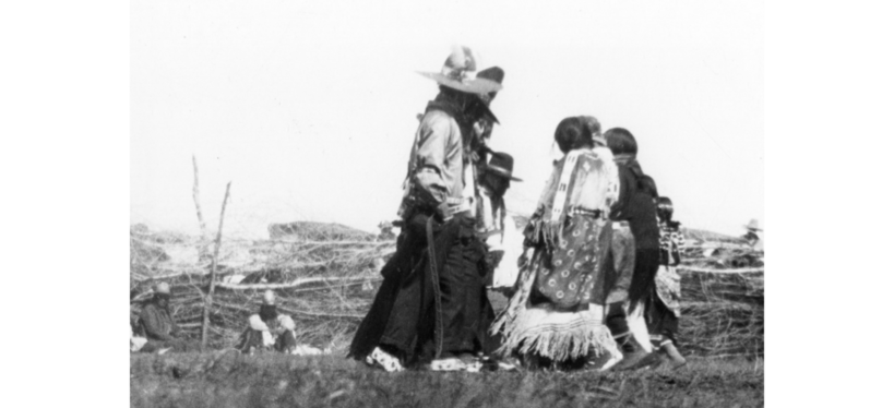
A group of Indians associated with the Posey War gathered for land allotment meetings in 1921 or 1922. Posey is standing second from the left.
All of this was accomplished because of a relatively insignificant affair that started when two young Utes robbed a sheep camp, killed a calf, and burned a bridge. The culprits voluntarily turned themselves in, stood trial, but then escaped from the sheriff’s grasp. The townspeople moved quickly not only to get the two boys but also Posey, who by this time had become synonymous with all of the ill will felt between the factions. To the townspeople, he was the living image of all Indians who were considered to be degraded or troublesome.
The newspapers played a significant role in developing this attitude, making Posey the lightning rod waiting to be struck. His name had appeared, in either direct or indirect accusation, with almost every negative incident that had occurred, and people often cited his band of Utes as the culprits in a misdeed. Posey was said to have been the man who pulled the trigger on Joe Aiken, the white fatality in the 1915 fight; Posey reportedly killed his brother Scotty because the latter wanted a peaceful settlement of that conflict; he also killed his wife by accident, though many settlers refused to believe it was a mishap; he avoided living on the reservation; and he was such a colorful individual that his threats, cajoling, and antics for food at a cabin door or out on the range often brought a stronger reaction to what would normally have been forgiven.85 Thus, the 1923 “war” served as the catalyst by which this “problem” could be removed.
In reality, the “war” was little more than a massive exodus of Utes and Paiutes fleeing their homes to escape into the rough canyon country of Navajo Mountain. Posey fought a rear-guard action to prevent capture, was eventually wounded, and watched his people get carted off to a barbed-wire compound set up in the middle of Blanding. He died a painful death a month later from his gunshot wound. When Posey’s death was certain, some of the Utes took Marshal J. Ray Ward to where the body was located in order to certify his death. The law officer buried the corpse and disguised the grave, but to no avail–it was exhumed at least twice.86
Of even greater import was the solution to the question of who controlled the ranges. The Posey incident served as an excuse to force land allotments on the Utes. Hubert Work, Secretary of the Interior, issued an order in April that both Ute groups stop their nomadic life and settle on individual land holdings. Moab’s Times-Independent reported,
Old Posey’s band, consisting of about 100 Indians will be given parcels of land located on or near Allen Canyon while Old Polk’s band, numbering about 85 men, women, and children will be allotted land along Montezuma Creek. The two bands which are not friendly, will be located some distance apart.87
The number of allotments in Montezuma Canyon varied. Ira Hatch, who owned and operated a trading post in this area, estimated that there were twenty-three Ute camps in Montezuma and Cross Canyons.88 Today, there are no Ute allotments in the former and only a few in the latter, the tribe having bought many of the individual holdings. In Allen Canyon, Ute families still own thirty allotments at the time of this writing.
Now that the end of a hunting-and-gathering lifestyle had reached an irreversible conclusion, agriculture became the supposed solution for the Utes. In reality, however, it faired just as badly. Ute farming efforts were on a subsistence level, failing to compete in the twentieth-century market economy with Anglos who had better land, equipment, and techniques. For instance, as late as the 1940s, the government farmer, E.Z. Black, plowed allotted lands in Allen Canyon that averaged around ten acres per family. He was also totally dependent upon the agents at Towaoc for teams, plows, seeds, and general financial backing. As soon as the funds dried up, so did the work on projects. Part of this problem arose because the Allen Canyon Utes in 1929 included only fourteen families. Their activities were so peripheral to those on the main reservation in Colorado that few people could muster sufficient funds or support for any sustained large-scale farming project.89 How much this bothered the people of Allen Canyon is difficult to determine, but they continued to wrestle with dire poverty–living in tents and depending on rations and other government subsidies.
Sheep, cattle, and horses presented a more culturally acceptable alternative to the Utes, but the battle for the ranges that took place during the first quarter of the twentieth century put a stop to free use of Montezuma Canyon, McCracken Mesa, and the plateaus surrounding Blue Mountain. Between the U.S. Forest Service, Bureau of Land Management, and private livestock companies, the lands encircling Allen Canyon were heavily controlled, forcing the Utes to keep their herds small and within certain limits. Physical and cultural restraints thus stifled the Ute economy. Clearing lands for white farmers, chopping wood for townspeople, and doing odd jobs for individual families served as only a temporary supplement in the hand-to-mouth existence of most of the area’s Ute Indians.
Another shift away from traditional Ute culture came in the form of the Native American Church. As part of a pan-Indian movement shared by many tribes across the nation, the church made inroads with the People by offering a system of more generalized Indian teachings. The Native American Church has its roots in Kiowa and Comanche tribal paraphernalia of the late nineteenth century. These Plains tribes provided the tepee, feather fan, drum, waterfowl, crescent-shaped altar, fire, and poker as standardized symbols within this belief system, while peyote, a hallucinogenic button from cactus initially found in Mexico, became the driving force within the ceremony. It provided the means through which God and supernatural powers could be made manifest to the participants involved in an all-night ceremony.90
The Native American Church entered San Juan County from Oklahoma via the Ute Mountain Ute Reservation. Two anthropologists, David E Aberle and Omer C. Stewart, conducted a detailed study of this phenomenon between 1946 and 1951 and identified four phases of development of these beliefs on the Ute and northern part of the Navajo reservations. Aberle and Stewart concluded that Towaoc Utes introduced the practices in the Mancos Creek and Aneth area; this was followed by a second phase in which Navajos working alongside Utes in the Civilian Conservation Corps, as well as others traveling to Towaoc for curing rites, encountered Native American Church practices. These phases took place between 1914 and 1938. Starting in 1936, peyote priests, or “Road Chiefs,” started visiting reservation communities south of the San Juan River, so that by 1951 there was an open flow of religious leaders from Oklahoma, Towaoc, and the Mancos/Aneth area throughout San Juan County. Aberle and Stewart infer that more than half of the population in the Aneth, Montezuma Creek, and region south of Bluff were practitioners in the Native American Church by this time.91
Not until the 1 950s did a Salt Lake City law firm under the leadership of Ernest L. Wilkinson make possible real financial assistance for the Utes of Colorado and Utah. Grounds for this aid were rooted in the past, when the government dispossessed the tribe of its lands–an estimated 15 million acres–beginning in 1868. In 1938 the Utes filed a suit claiming $40 million in losses. Wilkinson won a series of legal battles that settled on a final reparation of $32 million, giving 53 percent to the Utah Utes in the north and 47 percent to the Southern and Ute Mountain Utes in Colorado. The latter payment included recompense for the White Mesa people.92
The federal government approved the plan for the tribal governments to pay part of this money in a per capita settlement spread over a number of years. Although there were approximately 2,500 Utes living in both states, giving about $12,500 per person, Congress felt that part of these funds needed to be held back for investment in economic development. A long-range program for improvement of tribal facilities and projects still needed to be arranged.
To the 148 Utes living near Blanding, this translated into $1,025 per person over a two-year period, or an aggregate sum of $151,700–an unheard-of amount when most family incomes were well below $800 per year. Additional funds followed on a fairly regular basis, eventually averaging a total payment of $8,000 to each man, woman, and child. The initial reaction, reported in the newspapers with an obvious tinge of jealousy, indicated the Indians’ desire to own all those commodities their white neighbors had, such as cars, clothes, and high-priced food. Of greater import, however, were the funds set aside to improve housing, roads, and services.93
The Utes in Allen Canyon realized that their isolation was counterproductive, while others living on the outskirts of Blanding wanted to have better lands for farming and to use this money to build their livestock industry. The Ute agent, Elbert J. Floyd, met with the white people of Blanding and the area Utes to discuss the problems of relocation. All three parties determined that Allen Canyon was too small for the expansion of farming and industry and that the individual allotments were too large to allow for introduction of community-owned-and-operated modern conveniences. The Westwater community, located on BLM property on the outskirts of Blanding, was situated on land too rocky for farming, while building lots within the city limits were too expensive for Indian families to afford. Eventually, Ute-owned land eleven miles south of Blanding, now known as White Mesa, attracted Utes for settlement. Close enough to Blanding for those who wished to work there, yet far enough away to foster a sense of individual identity, the White Mesa site proved to be a good choice.94
Starting in the mid- 1950s, the Ute Mountain Rehabilitation Program, headquartered in Towaoc, provided funds for the construction of frame houses at White Mesa.95 By 1976, fifty homes dotted the grasslands that overlooked neighboring canyons. Soon another group of twenty-five houses, equipped with water and plumbing, were added to the community. Today, more than 100 buildings are found on the mesa. Electricity arrived in 1964, a 100,000-gallon water storage tank stood sentinel at the northern end of the community by the mid- 1970s, and bus service delivered Ute children to the schools in town. White Mesa had become an important social and unifying symbol of the modern Utes’ presence in southeastern Utah.96
Modernization has taken other forms. In 1977 the people of White Mesa elected a nine-member board and with the assistance of consultants formed the community organization called the Allen Canyon Ute Council, later named the White Mesa Ute Council. Because of the distance to Towaoc and the belief that the people from White Mesa were not receiving adequate consideration and representation in the larger body politic, the Utes elevated the White Mesa Ute Council to a more prominent role. In 1978 they hired Cleal Bradford, an experienced veteran in economic development, who had enjoyed a decade of working with the Utah Navajo Development Council before joining the Utes.
It did not take long to get things started. By 1981 the White Mesa community could boast a Headstart program, day care center, adult education classes, weekly health clinics, a senior-citizen program, a full-fledged recreation program, police protection from Towaoc, a monthly visit from a tribal judge, and local employment for twenty-five to thirty people. Four years later, area residents were also able to purchase some of their traditional grazing areas on north Elk Ridge, a move that brought deep satisfaction.97
Still another dramatic success occurred in schooling. A study completed by the tribe in 1977 showed that approximately one-third of the school-age children were receiving no formal education; another third were in foster care or detention centers; and half of the remaining third were living in other peoples’ homes under the LDS church’s placement program. Only one-sixth of those eligible were actually living at home and attending public schools. By 1983 the situation had changed dramatically: 42 percent of the entire population of White Mesa–including those enrolled in headstart, kindergarten through twelfth grade, college students, and people taking adult education classes–were now receiving some type of educational benefit and living on the mesa.98
Even with this growth and development, difficult problems still abounded. One of these centered around the hauling of radioactive uranium mill tailings from Monticello to the Energy Fuels company’s uranium mill, five miles north of White Mesa. This tentative repository site had been in operation since 1980 but had closed its doors to the processing of uranium in 1991–92. In 1994 its doors could be opened again as a storage site. To some of the people of White Mesa, other Native Americans, and some Anglos, this was unacceptable. They expressed anger over not having been consulted; they feared that the groundwater that flows to the south off of Blue Mountain to White Mesa would be contaminated; and they were concerned about the possibility of the digging of additional storage pits that would disturb Indian graves nearby. A protest march of 200 people, held on 22 September 1994, made use of the power of the media to broadcast the concerns. As a result, the tailings were never hauled to the site.99
While this incident proved successful, at least as far as opponents to the site were concerned, other problems have arisen. Recently, there has been a rapid series of changes in leadership since Cleal Bradford left. The people of White Mesa have struggled to find a permanent director who has both a vision of future progress and is able to work with the various factions within the community. Family groups wedded to different political agendas, combined with struggles for power between dissenters inside and outside of the community, have created a rocky political course for the present. However, if history is a good indicator of the future, the people of White Mesa will overcome these temporary setbacks as they set forth into the twenty-first century.
Today, the community of White Mesa, comprised of a population of around 350 people, has undergone substantial changes. It has modern housing with electricity and running water; some houses even sport a satellite dish. Many of the Ute people are employed in education and service industries such as schools and motels; some work for the tribal council; others help operate a cattle company and a store at White Mesa; while still others are employed at Towaoc in farming projects and in the local casino. Many are working towards economic self-sufficiency by obtaining job skills and college educations to help them compete in a rapidly changing economy.
Future plans include increased access to water from a seven-mile pipeline extending from Recapture Reservoir to White Mesa. This will allow the two underground wells that now service the community to act as a backup to the water treatment plant during periods of heavy use. Continued self-sufficiency of the cattle company through reinvestment from its sales and a greater emphasis in local education programs to help the youth are two other endeavors that have built pride and self-sufficiency. Finally, improving relations with and acceptance by the tribal council at Towaoc will continue to lead to more and better services. As the White Mesa Utes enter the twenty-first century, they can do so with optimism.
Yet despite all the new innovations, the land remains important to the Utes. From seventy-four-year-old Stella Eyetoo, who collects willows for baskets, to Edward Dutchie, Jr., who sits on the tribal council in Towaoc in an effort to improve conditions on White Mesa, to the children who play cowboys and Indians in the canyons where their forefathers hunted and fought to stay alive, the land will remain a central concern. The Utes of southeastern Utah have always depended upon these roots as a source of life that will continue to be nurtured as long as there is a Bear Dance, as long as their language is spoken, and as long as they think of themselves as the People.
1 Billy Mike, interview with Aldean Ketchum and Robert S. McPherson, October 13, 1993, transcript in possession of author.
2 Don D. Fowler and Catherine Fowler, Anthropology of the Numa: John Wesley Powell’s Manuscripts on the Numic People, Smithsonian Contributions to Anthropology 14 (Washington, D.C.: Smithsonian Institution, 1971), 78.
3 Pamela A. Bunte and Robert J. Franklin, From the Sands to the Mountains: Change and Persistence in a Southern Paiute Community (Lincoln: University of Nebraska Press, 1987), 227.
4 James A. Goss, “Culture-Historical Inference from Utaztekan Linguistic Evidence,” paper presented at Plenary Symposium on Utaztekan Prehistory of the Society for American Archaeology and the Great Basin Anthropological Conference, May 1966, 11, 27.
5 Ibid., 28.
6 Alan D. Reed, “Ute Cultural Chronology,” An Archaeology of the Eastern Ute: A Symposium, ed. Paul R. Nickens, Colorado Council of Professional Archaeology Occasional Papers Number 1 (Denver: 1988), 80–81; Winston Hurst, conversation with author, September 9, 1992.
7 Robert C. Euler, “Southern Paiute Archaeology,” American Antiquities 29 (January 1964): 380; Reed, “Ute Cultural Chronology,” 82; C.S. Fowler and D.D. Fowler, “The Southern Paiute: A.D 1400–1776,” The Protohistoric Period in the North American Southwest, A.D. 1350–1700, D.R. Wilcox and W.B. Masse, editors, Arizona State University Archaeological Research Papers Number 24, 129–62.
8 C. Melvin Aikens and Younger T. Witherspoon, “Great Basin Numic Prehistory Linguistics, Archaeology, and Environment,” Anthropology of the Desert West: Essays in Honor of Jesse D. Jennings, University of Utah Anthropological Papers Number 110 (1986), 9–20; Stephen C. Jett, “Testimony of the Sacredness of Rainbow Natural Bridge to Puebloans, Navajos, and Paiutes,” Plateau 45 (Spring 1973): 54.
9 Goss, “Culture-Historical Inference,” 29–30.
10 Ibid., 33–34.
11 S. Lyman Tyler, “The Yuta Indians Before 1680,” Western Humanities Review 8 (Spring 1951): 157, 160.
12 Donald G. Callaway, Joel C. Janetski, and Omer C. Stewart, “Ute,” in Handbook of North American Indians, Volume 11, Great Basin (Washington: Smithsonian Institution, 1986), 339.
13 Ibid., 366. The entire issue about use of Weenuche and Weeminuche is still very unclear. One elder explained that Weeminuche was fine and that Weenuche referred more to the prehistoric Ute peoples, while author Mary Jane Yazzie felt more comfortable with the name Weenuche.
14 T. Kelly and Catherine S. Fowler, “Southern Paiute,” in Handbook of North American Indians, Volume 11, Great Basin, 368, 396.
15 William R. Palmer, “Utah Indians Past and Present?An Etymological and Historical Study of Tribes and Tribal Names from Original Sources,” Utah Historical Quarterly 1 (April 1928): 52.
16 Omer C. Stewart, Culture Element Distributions: Ute-Southern Paiute (Berkeley: University of California Press, 1942), 236.
17 William R. Palmer, “San Juan Indians,” Palmer Collection Notes, Special Collections, Southern Utah University, Cedar City, 32.
18 Bunte and Franklin, Sands to the Mountains, 183, 232. Historic accounts by careful observers underscore these differences by saying that at times the Utes from the Montezuma Canyon-southwestern Colorado area would help whites control the Allen Canyon group and that the general term of “Paiute” was given to the latter, while those people nearer Colorado were called “Utes.” See Lyman Hunter, interview with Michael Hurst, February 21, 1973, Charles Redd Center for Western Studies, Brigham Young University, Provo, Utah, 2; Kumen Jones manuscript, Utah State Historical Society, Salt Lake City, 106; Stella Eyetoo, interview with Aldean Ketchum and Robert S. McPherson, December 21, 1994, tape in possession of authors.
19 E. L. Hewitt, “Field Notes 1906–09,” photocopy, Edge of the Cedars Museum, Blanding, Utah; Mike, interview; Chester Cantsee, Sr., interview with Aldean Ketchum and Robert S. McPherson, September 6, 1994, transcript in possession of author; John W. Van Cott, Utah Place Names (Salt Lake City: University of Utah Press, 1990), 264.
20 Julius S. Dailey, “Mancos Jim Mesa–San Juan County,” Utah Writers’ Project, August 11, 1942, Utah State Historical Society Library.
21 Fowler and Fowler, Anthropology of the Numa, 67–76.
22 See William R. Palmer, “The Pahute Fire Legend,” Utah Historical Quarterly 6 (April 1933): 62?64; Albert B. Reagan, “Mother Nature, “Albert B. Reagan Collection, Special Collections, Harold B. Lee Library, Brigham Young University, 64–65; Uintah Ouray Tribe, Stories of Our Ancestors: A Collection of Northern Ute Indian Tales (Salt Lake City: University of Utah Press, 1974), 22.
23 Carla Knight, “The Utes and Their Environment,” unpublished paper, used with permission, in possession of author.
24 Terry Knight, spiritual leader of the Ute Mountain Utes, interview with Mary Jane Yazzie and Robert S. McPherson, December 19, 1994, tape in possession of authors.
25 Marvin Kaufman Opler, “The Southern Ute of Colorado,” in Acculturation in Seven American Indian Tribes (New York: D. Appleton-Century Company, 1940), 141–42; Fowler and Fowler, Anthropology of the Numa, 66; Knight, interview.
26 Lindsay Amoss, Jr., “Ute Mountain Utes” (Ph.D. diss., University of California, 1951), 90.
27Frank Silvey, “Information on Indians,” September 26, 1936, Utah State Historical Society Library, 1–2. While Silvey’s work addresses this topic specifically, many of the sites mentioned are known from a scattering of historical documents that span one hundred years
28 Frank Silvey, “Indians in San Juan,” June 10, 1940, Silvey Files, Utah State Historical Society, 4.
29 Amoss, “Ute Mountain Utes,” 55–61; Ralph V. Chamberlain, “Some Plant Names of the Ute Indians,” American Anthropologist 2 (JanuaryMarch 1909): 27–37.
30 Amoss, “Ute Mountain Utes,” 49–51.
31 Opler, “The Southern Ute,” 141–45; Amoss, “Ute Mountain Utes,” 36–38.
32 Amoss, “Ute Mountain Utes,” 37–38; Chamberlain, “Some Plant Names,” 27–40; James Jefferson, Robert W. Delaney, and Gregory Thompson, The Southern Utes: A Tribal History (Ignacio, CO: Southern Ute Tribe, 1972): 72–73.
33 Mary Jane Yazzie, “Life and Traditions of the Utes of Avikan,” unpublished manuscript, in possession of author; Joseph G. Jorgensen, The Sun Dance Religion: Power for the Powerless (Chicago: University of Chicago Press, 1972), 23–25.
34 J. Weber, The Thos Trappers: The Fur Trade in the Far Southwest (Norman: University of Oklahoma Press, 1968), 23.
35 See G. Clell Jacobs, “The Phantom Pathfinder: Juan Maria Antonio de Rivera and His Expedition,” Utah Historical Quarterly 60 (Summer 1992): 20 1–23.
36 Donald C. Cutter, “Prelude to a Pageant in the Wilderness,” Western Historical Quarterly 8 (January 1977): 4–14; F.A. Barnes, “A Journey to the Rio del Tizon,” Canyon Legacy 9 (Spring 1991): 16–22; F.A. Barnes, “Update–Rivera’s 1765 Expedition,” Canyon Legacy 10 (Summer 1991): 31.
37 Joseph J. Hill, “Spanish and Mexican Exploration and Trade Northwest from New Mexico into the Great Basin, 1765–1853,” Utah Historical Quarterly 3 (January 1930): 5, 27–31.
38 Ibid., 90.
39 Ibid., 101–4.
40 Ted J. Warner, ed., The Dominguez-Escalante Journal: Their Expedition Through Colorado, Utah, and New Mexico in 1776 (Provo: Brigham Young University Press, 1976): 33.
41 Weber, Taos Trappers, 27; L.R. Bailey, Indian Slave Trade in the Southwest (Los Angeles: Westernlore Press, 1966), 143.
42 Bailey, Indian Slave Trade, 144; Hill, “Spanish and Mexican Exploration,” 17–18.
43 J. Lee Correll, Through White Men’s Eyes: A Contribution to Navajo History, Volume 3 (Window Rock: Navajo Heritage Center, 1979): 141, 147, 149, 154, 179–80.
44 C. Gregory Crampton, “Utah’s Spanish Trail,” Utah Historical Quarterly 47 (Fall 1979): 361–82; Steven K. Madsen, “The Spanish Trail Through Canyon Country,” Canyon Legacy 9 (Spring 1991): 23–29. For a detailed account of the trail see Leroy R. Hafen and Ann W. Hafen, The Old Spanish Trail: Santa Fe to Los Angeles (Glendale, CA: Arthur H. Clark Company, 1954).
45 G. Douglas Brewerton, “A Ride with Kit Carson,” Harpers New Monthly Magazine 8 (April 1854): 3 12–13; Conway B. Sonne, World of Wakara (San Antonio: Naylor Company, 1962), 135.
46 U.S., Congress, Senate, Report of the Secretary of War, John Garland to Army Headquarters, January31, 1858; J.G. Walker to Commander, September 20, 1859, 5. Ex. Doc 2, 36th Cong., 1st Sess., 339–40.
47 Brooks to Assistant Adjutant General, July 1 and 15, 1858, Record Group 98, Records of the United States Army Commander, Department of New Mexico, 1858, National Archives, Washington, D.C.
48 Dixon Miles to Nichols, September 3 and 8, 1858, Record Group 98, National Archives.
49 Electus Backus to William Lane, November 19, 1858, Record Group 98, National Archives; “Return of Spies and Guides,” Santa Fe Gazette, January 15, 1859, cited in Correll, Through White Men’s Eyes, 239.
50 T. Fauntleroy to Winfield Scott, January 29, 1860, Record Group 98, National Archives.
51 Paul Jones, interview with Aubrey Williams, January 19, 1961, Duke #712; George Martin, Sr., interview with David Brugge, March 22, 1961, Duke #9 13; Maggie Holgate, interview with Gary Shumway, June 13, 1968, Duke #956.
52 Major Albert Pfeiffer to A.K. Graves, December 10, 1866; Felipe Delgado to Office of Indian Affairs, January 7, 1866, Record Group 75, Letters Received by Office of Indian Affairs, New Mexico Superintendency, 1866 and 1868, National Archives.
53″Report of Special Agent J.K. Graves,” 1866, Report of the Secretary of the Interior, 39th Cong., 2nd Sess, House Ex. Doc. 1, 132; Archuleta to Graves, January 1, 1866, ibid., 141.
54 W.F.M. Amy to A.B. Norton, “Abiquiu Agency Report,” June 24, 1867, Report of the Commissioner of Indian Affairs, 206.
55 W.F.M. Army to Charles Mix, October 3, 1868, Letters Received, Office of Indian Affairs–New Mexico Superintendency, 1868 (hereafter cited as Letters Received–NM).
56 John Ayers, Abiquiu Agency Annual Report, August 16, 1869, Report of the Commissioner of Indian Affairs (hereafter cited as RCIA), 240–43; Ayers, Abiquin Agency Annual Report, September 3,1870, RCIA, 618–20. For a fuller treatment of this period for both the Utes and the Navajos see Robert S. McPherson, The Northern Navajo Frontier, 1860– 1900: Expansion through Adversity (Albuquerque: University of New Mexico Press, 1988).
57 J.B. Hanson, Abiquiu Agency Annual Report, September 11, 1871, RCIA, 408.
58 Calloway, Janetski, and Stewart, “Ute,” 355.
59″Treaty Between the United States of America and the Navajo Tribe of Indians” (Las Vegas: KC Publications, 1973), 22, 24. See McPherson, Northern Navajo Frontier for further information.
60 “Cattle Companies,” General File, Monticello Ranger District, Monticello, Utah, 2.
61 Edmund S. Carlisle to W.M. Clark, October 1, 1884; Carlisle to Major Hall (Fort Lewis, Colorado) November 8, 1884; John F. Tapping to William Clark, December 16, 1884, Record Group 75, Consolidated Ute Records, Denver Record Center (hereafter cited as Consol. Ute).
62 George M. Williams to Post Adjutant, December 11, 1889, National Archives, Record Group 75, Letters Received, 1881–1907, Bureau of Indian Affairs (hereafter cited as Letters Received–BIA).
63 Ibid.; Silvey, “Indians in San Juan,” 42.
64 Charles A. Bartholomew to David L. Shipley, October 13, 1890, Consol. Ute; Bartholomew “To the Navajo Indians,” November 11, 1890, Letters Received-BIA.
65 For further information see Faun McConkie Tanner, The Far Country–A Regional History of Moab and La Sal, Utah (Salt Lake City: Olympus Publishing Company, 1976): 105–46; Don D. Walker, “Cowboys, Indians, and Cavalry–A Cattleman’s Account,” Utah Historical Quarterly 34 (Summer 1966): 255–62; Cornelia Perkins, Marian Nielson, and Lenora Jones, Saga of San Juan (Salt Lake City: Mercury Publishing Company, 1957), 234–44; and Albert R. Lyman, “History of San Juan County, 1879–1917,” manuscript, Harold B. Lee Library, Brigham Young University, 22–23,41-42.
66 Edmund S. Carlisle to William M. Clark, October 1, 1884, Ute Agency Files, Federal Record Center, Denver.
67 Edmund S. Carlisle to William M. Clark, December 30, 1884, DRC–Ute Agency. See Walker, “Cowboys, Indians, and Cavalry,” 255–62.
68Larabee to Thomas McCunniff, June 17,1889, Consol. Ute Agency; “Report of Brigadier-General Crook,” Report of the Secretary of War, 1887, 1st Sess., 50th Cong., 133.
69 Frank Moss Papers, Special Collections, Marriott Library, University of Utah, Salt Lake City, 55.
70 Ibid., 198.
71 Ibid., 202.
72 Christian L. Christensen, “When the Utes Invaded Utah,” Times-Independent (Moab), August 3, 1933,4.
73 Report of Agency in Colorado–Southern Utes, RCIA, 1898, 140.
74 Report of Agent in Colorado–Southern Ute Agency, RCIA, 1896, 132.
75 Report of Agent for Southern Ute Agency, RCIA, 1900, 2 13–14; Report of Agent for Southern Ute Agency, Annual Report of Department of the Interior Fiscal Year Ending June 30, 1901, 205.
76 For a detailed explanation of this event and others surrounding it see Forbes Parkhill, The Last of the Indian Wars (New York: Crowell- Collier Publishing Company, 1961).
77″Armed Posse is After Renegade,” Grand Valley Times, February 19, 1915, 1.
78 “1 White and 3 Piutes Are Killed,” Grand Valley Times, February 26, 1915, 1.
79 “Scott Captures Renegade Indians,” Grand Valley Times, March 26, 1915, 2.
80 James C. Wilson to Agent A.H. Symons, January 5, 1917, James McLaughlin Papers, Microfilm #8, Denver Public Library (hereafter cited as McLaughlin Papers).
81 James McLaughlin to Indian Commissioner Cato Sells, January 18 and 20, 1917, McLaughlin Papers.
82 Undersigned of Bluff to Major James McLaughlin, January 12, 1917, McLaughlin Papers.
83 A.H. Symons to Major James McLaughlin, February 3, 1917, McLaughlin Papers.
84 For a lengthier treatment of the Posey incident see “Paiute Posey and the Last White Uprising,” Utah Historical Quarterly 53 (Summer 1985): 248–67; and Albert R. Lyman, The Outlaw of Navaho Mountain (Salt Lake City: Publishers Press, 1986).
85 “Paiute Indian Chief Slays His Brother,” Grand Valley Times, March 5, 1915, 7; “Indians Refuse to Go to Reservation, Is Report,” Grand Valley Times, June 4, 1915, 1; “Posey at Bluff,” Grand Valley Times, June 11, 1915, 1.
86 Ibid., “Forest Ranger First to Find Posey’s Body,” Grand Valley Times, May 17, 1923, 1.
87 “Government Allots Farms and Livestock to San Juan Paiutes,” Times-Independent, April 19, 1923, 1.
88 Mr. and Mrs. Ira Hatch, interviewed by Floyd A. O’Neil and Gregory C. Thompson, September 10, 1970, Doris Duke Oral History Project, Special Collections, Marriott Library, University of Utah, 9.
89 See “Farmers Reports: Allen Canyon, 1925–27,” Record Group 75, Consolidated Ute Agency, National Archives, Denver; Agent E.J. Peacore to Commissioner of Indian Affairs, March 12, 1929, Record Group 75, Letters Received, Bureau of Indian Affairs, National Archives.
90 For a detailed explanation of the growth of the Native American Church see David F. Aberle, The Peyote Religion Among the Navaho (Chicago: University of Chicago Press, 1982).
91 David F. Aberle and Omer C. Stewart, Navaho and Ute Peyotism– A Chronological and Distributional Study, University of Colorado Studies Number 6 (Boulder: University of Colorado Press, 1957), 25–27, 90.
92 “Utes Agree on Money Division,” Desert Magazine 13 (June 1950): 38; “Ute Indians Awarded $31,000,000 Settlement,” San Juan Record, July 20, 1950, 1; “Ute Indians to Receive Payment,” San Juan Record, September 6, 1951,5.
93 Juan Piutes Have Pay Day,” San Juan Record, April 24, 1952,3; “Ute Land Settlement Fund Allocation Set by Council,” San Juan Record, June 26, 1952, 1.
94 “Indian Meeting at Blanding Takes up Many Problems Facing Tribe Including Living Conditions in the Area,” San Juan Record, 6 November 1952, 1; “Rehabilitation of Indians to Be a Reality,” San Juan Record, 19 December 1952, 1.
95 “Ute Indian Tribe Building New Homes,” San Juan Record, October 14, 1954, 6.
96 “Progress on White Mesa,” San Juan Record, 29 January 1976, 8.
97 “White Mesa Council Celebrates,” San Juan Record, 9 April 1981, 6; “White Mesa Council Nominated for International Exposition,” San Juan Record, 21 July 1983, 1; Cleal Bradford, conversation with author, 27 June 1996.
98 Cleal Bradford, conversation with author, 27 June 1996.
99 “White Mesa Community Marches to Protest Mill Tailings Truck Haul–Washington Judge Hears Case,” Blue Mountain Panorama, 28 September 1994, 1; “Ute, Navajos Protest Tailings Plan,” San Juan Record, 28 September 1994, 12.
Chapter 7, “The Navajos of Utah” Back to General Information Landing Page