
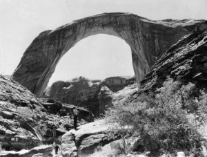
Rainbow Bridge National Monument
Joseph M. Bauman, Jr.
Utah History Encyclopedia, 1994
The Colorado Plateau is a physiographic province encompassing 130,000 square miles of the Four Corners states, including Utah’s southeastern quarter. Arguably, it is the least-tamed country remaining in the lower forty-eight states.
It is a land of outstanding natural beauty and ecological diversity. The high, semi-arid region is actually a gigantic basin studded with a variety of landforms, ranging from 5,000 to 11,000 feet in elevation. There are rugged plateaus, slot canyons, mountains, river gorges with whitewater rapids, the Grand Canyon, and nearly every conceivable type of desert landscape. Rodney D. Millar and Joan Degiorgio wrote in June 1986 in the state of Utah’s proposal to designate the region as a World Heritage Site: “It is easily the most colorful area of comparable size on the earth.”
The variety of the region extends to its life as well as its geology. Animals and plants have adapted to the exposed rock strata and harsh climatic conditions. Separated by chasms, clinging to shelves of exposed rock, or making their living in roaring rivers, they evolved into unique species like the Colorado squawfish, a minnow that can reach nearly six feet in length.
Through the millennia, ancient people also lived here, leaving behind artifacts as simple as spear points 10,500 years old and as sophisticated as the great 1,000-year-old stone villages of the Anasazi culture. More recently Utes, Paiutes, and Navajos moved in, and these tribes remain important parts of the modern culture.
The first Europeans to reach the Grand Canyon section of the Colorado Plateau were Spaniards under Garcia Lopez de Cardenas, part of Francisco Vazquez de Coronado’s quest for the “Seven Cities of Cibola.” Cardenas reached the Hopi towns of Arizona, and then the Grand Canyon, in 1540. The next recorded visit there was on 26 June 1776 by Francisco Garces, a missionary.
The same year, an expedition led by Fathers Francisco Atanasio Dominquez and Silvestre Velez de Escalante set out to find a better route between the Catholic missions at Santa Fe, New Mexico, and Monterey, California. They spent nearly all of the period from 11 September until 7 November 1776 in what is now Utah. They failed to reach California but discovered a valuable crossing of the Colorado River and explored as far into Utah’s interior as Utah Lake.
Traders in slaves and livestock established the Old Spanish Trail from Santa Fe to central Utah early in the nineteenth century. It arched around the San Rafael Reef and onto the Wasatch Plateau. At first, it terminated around Utah Lake; eventually, it headed south and west and reached Los Angeles–1,200 miles from Santa Fe. It was in use from at least 1813 until the middle of the nineteenth century, when it was supplanted by the more northern Mormon Trail.
American explorers pushed into the Colorado Plateau, often in grave danger from the weather and hostile Native Americans. They included members of expeditions led by Captain John Williams Gunnison, massacred along with seven men in his command, in central Utah by Paiutes, October 1853; John Charles Fremont, who got lost in the snows of the Aquarius Plateau, at the cost of one man dead, before stumbling into Parowan in February 1854; J. N. Macomb of the Army Topographical Engineers, 1859; and Lt. George M. Wheeler, who explored the western and southern sections of the Grand Canyon in 1869 and 1871.
William Culp Darrah
Powell’s Second Expedition. William Culp Darrah Collection.
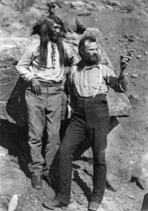
Probably the most daring expeditions were those of John Wesley Powell. His small group of adventurers traveled the Green and Colorado rivers in 1869, working their way through the canyons in wooden boats. Three men tried to hike out overland in late August 1869, shortly before the remaining six rode the rapids out of the canyons and returned to safety; the three were killed by Indians. Powell led another team to explore the river canyons in 1871-72. Eventually, federal surveys operated throughout the region.
In February 1872 Powell’s photographer, E.O. Beaman, quit the second expedition, leaving Kanab on his own photography trip. He made his way through the Buckskin Mountains, into Kanab Wash, and reached the Colorado River. Sometimes hiring a helper from local ranching families but often working alone, he hauled his heavy camera and supplies by horse and mule, and took some of the first photographs of the Grand Canyon. Beaman also photographed the Hopi towns.
In 1889-90, railroad promoters Robert B. Stanton and Frank M. Brown led a foolhardy survey along the canyons of the Green and Colorado rivers, trying to prove that a railroad could be built through the Grand Canyon. Three men, including Brown, drowned when their boats capsized.
Earlier, Mormons had set out in 1855 from Manti, charged with converting the Indians and settling the region near present-day Moab. Three months after they arrived, on 23 September 1855 Indians attacked, killing three and wounding another. The survivors returned to Manti.
Throughout the last half of the nineteenth century, gold miners, settlers, ranchers, missionaries, soldiers, and outlaws pushed into the wilderness of the Colorado Plateau. During the uranium boom of World War II through the 1950s, prospectors gouged out mines and built tarpaper shacks in scattered locations. Their trails still criss-cross much of the landscape.
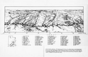
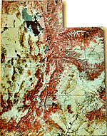
Colorado Plateau Map (before the Glen Canyon Dam was built)
Today, with Interstate 70 cutting through the region and numerous secondary roads offering easy access, the area is a tourist’s mecca of numerous parks, monuments, and wilderness regions. Tourism, ranching, mining, and farming are some of the main sources of income in the area.
Among the most spectacular protected areas of the Plateau are Canyonlands, Arches, Capitol Reef, Bryce Canyon, Zion, Grand Canyon, and Mesa Verde national parks; Rainbow Bridge, Canyon de Chelly, Natural Bridges, and Wupatki national monuments; Kodachrome Basin State Reserve, Deadhorse Point State Park, and Glen Canyon National Recreation Area.
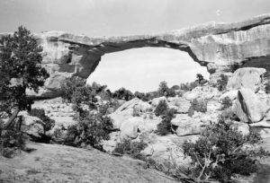
Owachomo Bridge
See: Gregory Crampton, Land of Living Rock (1985); F. A. Barnes, Utah Canyon Country (1986); and Deseret: 1776-1976, Henry A. Smith (1975).
Utah Topographical Map